File:Hurricane Florence over the Atlantic Ocean (MODIS 2018-09-11).jpg

Original file (7,012 × 5,635 pixels, file size: 5.22 MB, MIME type: image/jpeg)
Captions
Captions
Summary
[edit].jpg&action=edit§ion=1)
| Description |
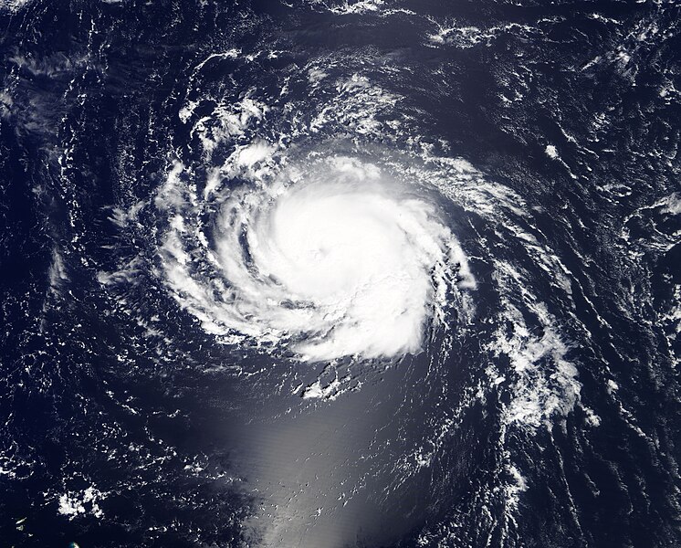
English: On September 9, 2018, a languishing Atlantic storm system began to re-intensify as it took aim on the East coast of the United States.
As the day opened, Florence was a tropical storm shaking off wind shear. By the close of the day, Hurricane Florence was a rapidly intensifying Category 1 storm on the Saffir-Simpson Hurricane Wind Scale with maximum sustained winds of 90 mph (150 km/h). According to the 11:00 p.m. EDT advisory by the National Hurricane Center (NHC), Hurricane Florence was located about 685 mi (110 km) southeast of Bermuda and about 560 mi (905 km) northeast of the northern Leeward Islands. It was moving westward at 7 mph (11 km/h). Through the next day, Florence continued to intensify. At 5:00 p.m. EDT September 10, the NHC reported that the maximum sustained winds had reached 140 mph (220 km/h), bringing the storm to Category 4 strength. Florence was located about 525 mi (845 km) south-southeast of Bermuda and 1,170 mi (1,880 km) east-southeast of Cape Fear, North Carolina. It was moving to the west-northwest at about 13 mph (20 km/h). Hurricane-force winds extended outward up to 40 miles (65 km) from the center and tropical-storm-force winds extended outward up to 150 miles (240 km). As strong as this storm is as of the evening of September 10, it is predicted to strengthen over the next 36 hours, potentially to a Category 5 storm, with winds greater than 157 mph (252 km/h). Depending on the action of a steering ridge that is forming over the United States and disturbances in the Caribbean, there is some potential wind shear that may develop to slightly decrease Hurricane Florence’s strength before it makes landfall. Landfall is expected on Thursday, September 13, most likely in northern South Carolina or North Carolina, but the entire coastline from the Delmarva Peninsula (where Delaware, Maryland, and Virginia meet) to South Carolina are at risk for landfall. Storm surge - likely to be large and dangerous – is expected to start reaching the beaches as early as September 11. This is a very large storm. Winds will be most dangerous close to the center, but extremely heavy rainfall is expected to bring severe flooding to a wide region, especially if the storm stalls just inland. As of September 10, South Carolina, North Carolina, Virginia, and Maryland have declared states of emergency. The Moderate Resolution Imaging Spectroradiometer (MODIS) on board NASA’s Terra satellite acquired a true-color image of Hurricane Florence on September 9, 2018, as it was beginning to intensify in the Atlantic Ocean, moving towards the coast of the United States. |
||
| Date | Taken on 9 September 2018 | ||
| Source |
Hurricane Florence over the Atlantic Ocean (direct link)
|
||
| Author | MODIS Land Rapid Response Team, NASA GSFC |
| This media is a product of the Terra mission Credit and attribution belongs to the mission team, if not already specified in the "author" row |
Licensing
[edit].jpg&action=edit§ion=2)
| This file is in the public domain in the United States because it was solely created by NASA. NASA copyright policy states that "NASA material is not protected by copyright unless noted". (See Template:PD-USGov, NASA copyright policy page or JPL Image Use Policy.) | ||
 |
Warnings:
|
File history
Click on a date/time to view the file as it appeared at that time.
| Date/Time | Thumbnail | Dimensions | User | Comment | |
|---|---|---|---|---|---|
| current | 01:31, 17 February 2024 | | 7,012 × 5,635 (5.22 MB) | OptimusPrimeBot (talk | contribs) | #Spacemedia - Upload of http://modis.gsfc.nasa.gov/gallery/images/image09112018_250m.jpg via Commons:Spacemedia |
You cannot overwrite this file.
File usage on Commons
There are no pages that use this file.
.jpg&oldid=856346658)