File:Hurricane Dorian (MODIS 2019-08-31).jpg

Original file (5,201 × 4,478 pixels, file size: 2.25 MB, MIME type: image/jpeg)
Captions
Captions
Summary
[edit].jpg&action=edit§ion=1)
| Description |
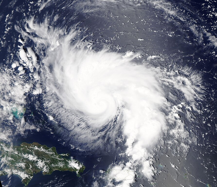
English: At of 8:30 pm EDT on August 30 the National Hurricane Center (NHC) advised that Hurricane Dorian had strengthened an extremely dangerous Category 4 storm, packing maximum sustained winds of 130 mph (215 km/h). Dorian was located about 400 miles (645 km) east of the northwestern Bahamas and about 575 miles (925 km) east of West Palm Beach, Florida.
At the same time, and despite Dorian’s center sitting more than 500 miles (800 km) away, Florida Congresswoman Donna Shalala reported on CNN that flooding was already affecting Miami Beach, thanks to the storm and a “king tide”. According to WFTV9 News in Orlando, Florida, a king tides (unusually high tide that happen when the moon is closest to the Earth) are taking place now in Florida and are likely to continue through Labor Day. At 11:00 p.m. EDT (0300 UTC), Hurricane Dorian had strengthened, carrying 140 mph (220 km/h) maximum sustained winds. It had moved a bit closer and was now located about 545 mi (800 km) east of West Palm Beach, Florida and about 275 miles (605 km) east of the northwestern Bahamas. Dorian was moving west-northwest at 10 mph (17 km/h). The NHC forecasts a slower west-northwestward motion should begin within a few hours and continue into early next week. On this track, the core of Dorian is expected to move over the Atlantic well north of the southeastern and central Bahamas on through August 31, be near or over the northwestern Bahamas on September 1, and be near the Florida east coast late on September 2. Some additional strengthening is possible through August 31. Although fluctuations in intensity are possible over the next few days, Dorian is expected to remain a powerful hurricane. A life-threatening storm surge will raise water levels by as much as 10 to 15 feet above normal in areas of onshore winds in the northwestern Bahamas. Near the coast, the surge will be accompanied by large and destructive waves. The NHC also advises that Dorian is expected to produce the following rainfall accumulations this weekend through the middle of the first week of September: Northwestern Bahamas, 10-15 inches with isolated areas of 20 inches and coastal sections of the southeast United States, 6-12 inches isolated up to 18 inches. The Moderate Resolution Imaging Spectroradiometer (MODIS) on board NASA’s Aqua satellite acquired a true-color image of Hurricane Dorian as it was strengthening on August 29, 2019. |
||
| Date | Taken on 29 August 2019 | ||
| Source |
Hurricane Dorian (direct link)
|
||
| Author | MODIS Land Rapid Response Team, NASA GSFC |
| This media is a product of the Aqua mission Credit and attribution belongs to the mission team, if not already specified in the "author" row |
Licensing
[edit].jpg&action=edit§ion=2)
| This file is in the public domain in the United States because it was solely created by NASA. NASA copyright policy states that "NASA material is not protected by copyright unless noted". (See Template:PD-USGov, NASA copyright policy page or JPL Image Use Policy.) | ||
 |
Warnings:
|
File history
Click on a date/time to view the file as it appeared at that time.
| Date/Time | Thumbnail | Dimensions | User | Comment | |
|---|---|---|---|---|---|
| current | 03:05, 17 February 2024 | | 5,201 × 4,478 (2.25 MB) | OptimusPrimeBot (talk | contribs) | #Spacemedia - Upload of http://modis.gsfc.nasa.gov/gallery/images/image08312019_250m.jpg via Commons:Spacemedia |
You cannot overwrite this file.
File usage on Commons
There are no pages that use this file.
.jpg&oldid=852750794)