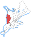
File:Huron-Bruce.png
From Wikimedia Commons, the free media repository
Jump to navigation
Jump to search

Size of this preview: 476 × 599 pixels. Other resolutions: 191 × 240 pixels | 381 × 480 pixels | 682 × 858 pixels.
Original file (682 × 858 pixels, file size: 81 KB, MIME type: image/png)
File information
Structured data
Captions
Captions
Add a one-line explanation of what this file represents
Summary
[edit]| DescriptionHuron-Bruce.png | |
| Date | 23 October 2005 (original upload date) |
| Source | Own work |
| Author | SimonP at English Wikipedia |
Licensing
[edit]| Public domainPublic domainfalsefalse |
| This work has been released into the public domain by its author, SimonP at English Wikipedia. This applies worldwide. In some countries this may not be legally possible; if so: SimonP grants anyone the right to use this work for any purpose, without any conditions, unless such conditions are required by law.Public domainPublic domainfalsefalse |
Original upload log
[edit]The original description page was here. All following user names refer to en.wikipedia.
- 2005-10-23 02:22 SimonP 1046×1215 (34299 bytes) Map of the [[Huron—Bruce]] electoral district. Based on [[User:Earl Andrew|]]'s [[User:Earl Andrew/maps|maps]], created by ~~~.
File history
Click on a date/time to view the file as it appeared at that time.
| Date/Time | Thumbnail | Dimensions | User | Comment | |
|---|---|---|---|---|---|
| current | 04:54, 24 October 2015 |  | 682 × 858 (81 KB) | Djvarley (talk | contribs) | New map to reflect new boundaries of electoral districts after the 42nd Canadian general election on October 19, 2015. The boundaries of Huron—Bruce itself were not changed. |
| 13:19, 25 December 2011 |  | 1,046 × 1,215 (33 KB) | MGA73bot2 (talk | contribs) | {{BotMoveToCommons|en.wikipedia|year={{subst:CURRENTYEAR}}|month={{subst:CURRENTMONTHNAME}}|day={{subst:CURRENTDAY}}}} == {{int:filedesc}} == {{Information |description={{en|1=Map of the Huron—Bruce electoral district. Based on [[ |
You cannot overwrite this file.
File usage on Commons
The following page uses this file:
File usage on other wikis
The following other wikis use this file:
- Usage on en.wikipedia.org
- Usage on fr.wikipedia.org
- Usage on www.wikidata.org
Metadata
This file contains additional information such as Exif metadata which may have been added by the digital camera, scanner, or software program used to create or digitize it. If the file has been modified from its original state, some details such as the timestamp may not fully reflect those of the original file. The timestamp is only as accurate as the clock in the camera, and it may be completely wrong.
| PNG file comment |
|
|---|---|
| Horizontal resolution | 28.35 dpc |
| Vertical resolution | 28.35 dpc |
| File change date and time | 04:53, 24 October 2015 |