File:Huntington Rural Cemetery.jpg

Original file (1,070 × 1,600 pixels, file size: 544 KB, MIME type: image/jpeg)
Captions
Captions
| Description |
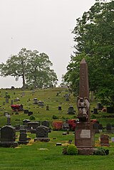
As densely populated Manhattan can be overwhelming, I decided to take a day trip to the suburbs. As I had never ventured into Long Island before, I took a ride on the Long Island Rail Road. I decided to come all the way out to Huntington in Suffolk County, simply due to Huntington being the place where my pop music idol Mariah Carey grew up, and the Long Island Rail Road having previously been Mariah's teenage-era run to/from Manhattan to meet with musician friends; I wanted to pay tribute to the town and the atmosphere that had shaped her and her music. Other celebrities, such as Billy Joel and Lindsay Lohan, have also called Huntington home at one time or another. A gloomy, rainy day, so a cemetery photo is quite appropriate to capture the day's mood. At least I can be thankful that unlike my other early idols Michael Jackson and Whitney Houston, both of whom are now deceased, Mariah Carey is still alive and very well, and won't be joining the ranks of the tombstones here anytime soon. |
||
| Date | |||
| Source | Flickr: Huntington Rural Cemetery | ||
| Author | InSapphoWeTrust | ||
| Permission (Reusing this file) |
This file is licensed under the Creative Commons Attribution-Share Alike 2.0 Generic license.
|
| Camera location | | View this and other nearby images on: OpenStreetMap |
|---|
File history
Click on a date/time to view the file as it appeared at that time.
| Date/Time | Thumbnail | Dimensions | User | Comment | |
|---|---|---|---|---|---|
| current | 04:31, 23 October 2012 | | 1,070 × 1,600 (544 KB) | Flickr upload bot (talk | contribs) | Uploaded from http://flickr.com/photo/56619626@N05/8111821125 using Flickr upload bot |
You cannot overwrite this file.
File usage on Commons
The following page uses this file:
- File:Huntington Rural Cemetery (8111821125).jpg (file redirect)
.jpg&redirect=no)