File:Humpback bridge201004-002.jpg
Jump to navigation
Jump to search

Size of this preview: 800 × 533 pixels. Other resolutions: 320 × 213 pixels | 640 × 427 pixels | 1,024 × 683 pixels | 1,280 × 853 pixels | 2,560 × 1,707 pixels | 8,256 × 5,504 pixels.
Original file (8,256 × 5,504 pixels, file size: 35.5 MB, MIME type: image/jpeg)
Captions
Captions
Add a one-line explanation of what this file represents
Summary
[edit]
| Description |
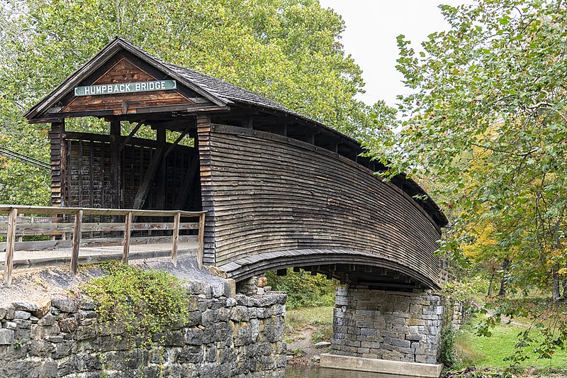
English: The Humpback Covered Bridge. The Humpback Covered Bridge, located three miles west of Covington, Va., is one of the few remaining covered bridges in the U.S. that was built higher in the middle than on either end; hence the name of "humpback". The humpback is four feet higher in the center of the bridge than are the ends. The bridge was built in 1857 and is also the oldest remaining covered bridge in the state of Virginia. The 109-foot bridge, built of white oak and hickory, spans a tributary of the Jackson River known as Dunlap Creek. Three bridges stood at approximately the same location as Humpback Covered Bridge does today. The first was built in the 1820s and was destroyed by a flood in 1837. A second, built the next year, was also destroyed by a flood on July 13, 1842. The third bridge collapsed in 1856 due to heavy use and fatigue from weathering. None of these earlier bridges were either arched or covered. The Humpback Covered Bridge was used from 1857 to 1929, when a steel truss bridge was built for U.S. Route 60 immediately to the north. In 1953, the Virginia Highway Department matched a $5,000 fund that had been raised by the Covington Business and Professional Women's Club and the Covington Chamber of Commerce. Five acres surrounding the bridge were purchased and a small wayside park which opened in 1954 was built, allowing easier access. On October 1, 1969, the bridge was listed in the National Register of Historic Places, and in 2012 it was designated a National Historic Landmark. Midland Trail, Covington, Va. 4 October 2020
|
||
| Date | |||
| Source | Own work | ||
| Author | Alan P. Goldstein |
| Camera location | | View this and other nearby images on: OpenStreetMap |
|---|
Licensing
[edit]
I, the copyright holder of this work, hereby publish it under the following license:
This file is licensed under the Creative Commons Attribution-Share Alike 4.0 International license.
- You are free:
- to share – to copy, distribute and transmit the work
- to remix – to adapt the work
- Under the following conditions:
- attribution – You must give appropriate credit, provide a link to the license, and indicate if changes were made. You may do so in any reasonable manner, but not in any way that suggests the licensor endorses you or your use.
- share alike – If you remix, transform, or build upon the material, you must distribute your contributions under the same or compatible license as the original.

|
This image was uploaded as part of Wiki Loves Monuments 2020.
|
 |
File history
Click on a date/time to view the file as it appeared at that time.
| Date/Time | Thumbnail | Dimensions | User | Comment | |
|---|---|---|---|---|---|
| current | 17:59, 11 October 2020 | | 8,256 × 5,504 (35.5 MB) | Goldpost2 (talk | contribs) | Uploaded own work with UploadWizard |
You cannot overwrite this file.
File usage on Commons
There are no pages that use this file.