File:Human occupation areas in Alcalá de Henares - map-es.svg
Jump to navigation
Jump to search

Size of this PNG preview of this SVG file: 800 × 533 pixels. Other resolutions: 320 × 213 pixels | 640 × 427 pixels | 1,024 × 683 pixels | 1,280 × 853 pixels | 2,560 × 1,707 pixels | 1,680 × 1,120 pixels.
Original file (SVG file, nominally 1,680 × 1,120 pixels, file size: 333 KB)
Captions
Captions
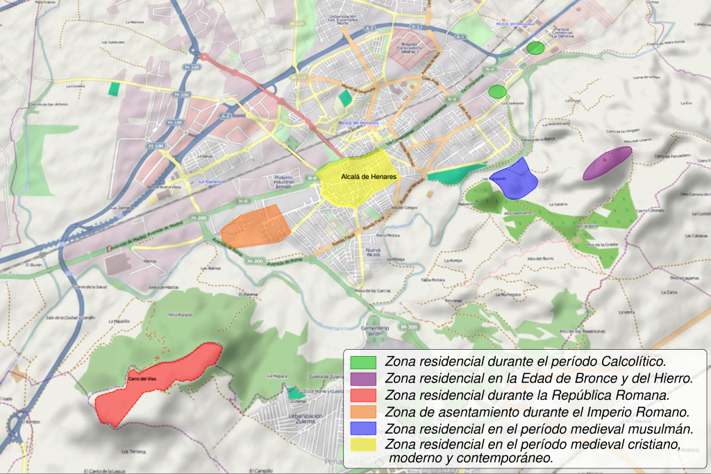
Human occupation areas in Alcalá de Henares (Community of Madrid - Spain).
Summary
[edit]| Description |
English: Map of human occupation in Alcalá de Henares (Complutum during the Roman times), near Madrid, Spain.
English (en):
Residential area during the Calcolithic period (Copper Age). Residential area during the Bronze and Iron Age. Residential area during the Roman Republic. Occupation area during the Roman Empire. Residential area during the Medieval Muslim period. Residential area during the Medieval Christian period, the Modern Age and today.
Español: Mapa de los asentamientos humanos en Alcalá de Henares (Complutum en la época romana) en la Comunidad de Madrid - (España):
español (es):
Zona residencial durante el período Calcolítico (Edad del Cobre). Zona residencial durante la Edad de Bronce y del Hierro. Zona residencial durante la República Romana. Zona de asentamiento durante el Imperio Romano. Zona residencial durante el periodo medieval musulmán. Zona residencial durante el período medieval cristiano, la Edad Moderna y en la actualidad.
Français : Carte des zones d'habitations ou d'occupations d'Alcalá de Henares, près de Madrid, Espagne. Le site s'appelait Complutum à l'époque romaine.
français (fr):
Zone d'habitation à l'époque Chalcolithique (âge du cuivre). Zone d'habitation à l'âge du bronze et à l'âge du fer I. Zone d'habitation durant la République romaine. Zone d'occupation durant l'Empire romain. Zone d'habitation à l'époque médiévale musulmane. Zone d'habitation à l'époque médiévale chrétienne, moderne et contemporaine.
|
||
| Date | |||
| Source | |||
| Author |
|
||
| Other versions | |||
| SVG | W3C-validity not checked.
|
||
| Graphic Lab |


| Camera location | | View this and other nearby images on: OpenStreetMap |
|---|
Licensing
[edit]
I, the copyright holder of this work, hereby publish it under the following license:
This file is licensed under the Creative Commons Attribution-Share Alike 4.0 International license.
- You are free:
- to share – to copy, distribute and transmit the work
- to remix – to adapt the work
- Under the following conditions:
- attribution – You must give appropriate credit, provide a link to the license, and indicate if changes were made. You may do so in any reasonable manner, but not in any way that suggests the licensor endorses you or your use.
- share alike – If you remix, transform, or build upon the material, you must distribute your contributions under the same or compatible license as the original.
File history
Click on a date/time to view the file as it appeared at that time.
| Date/Time | Thumbnail | Dimensions | User | Comment | |
|---|---|---|---|---|---|
| current | 19:33, 9 August 2020 | | 1,680 × 1,120 (333 KB) | Sémhur (talk | contribs) | Intento 3 |
| 08:40, 8 August 2020 |  | 1,680 × 1,120 (337 KB) | Raimundo Pastor (talk | contribs) | ¿Por qué no aparece el texto en español? ¿quién puede ayudar? | |
| 08:06, 8 August 2020 |  | 1,680 × 1,120 (340 KB) | Raimundo Pastor (talk | contribs) | Otro intento para que se vea el texto en español. | |
| 20:14, 6 August 2020 |  | 1,680 × 1,120 (340 KB) | Sémhur (talk | contribs) | Intento 2 | |
| 20:11, 6 August 2020 |  | 1,680 × 1,120 (340 KB) | Sémhur (talk | contribs) | Intento | |
| 18:58, 6 August 2020 |  | 1,680 × 1,120 (337 KB) | Raimundo Pastor (talk | contribs) | File uploaded using svgtranslate tool (https://svgtranslate.toolforge.org/). Added translation for es. | |
| 11:09, 6 August 2020 |  | 1,680 × 1,120 (337 KB) | Raimundo Pastor (talk | contribs) | Uploaded own work with UploadWizard |
You cannot overwrite this file.
File usage on Commons
The following 3 pages use this file:
File usage on other wikis
The following other wikis use this file:
- Usage on es.wikipedia.org