File:HulaArabic.png
Jump to navigation
Jump to search

Size of this preview: 392 × 599 pixels. Other resolutions: 157 × 240 pixels | 530 × 810 pixels.
Original file (530 × 810 pixels, file size: 97 KB, MIME type: image/png)
Captions
Captions
Add a one-line explanation of what this file represents
| Description |
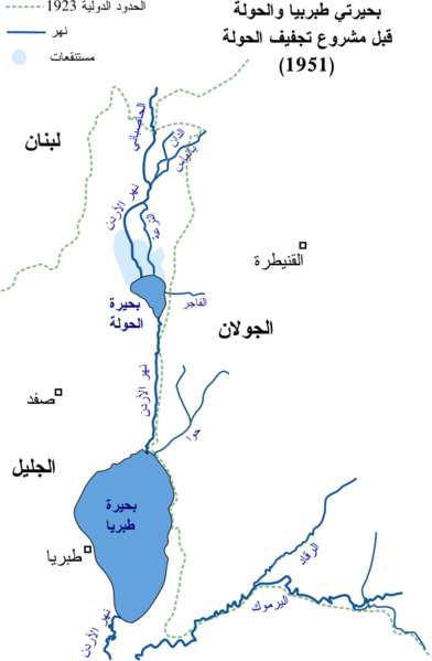
العربية: خارطة موارد المياه في شمالي شرقي الجليل قبل مشروع تجفيف الحولة في 1951 English: Arabic map of water sources NE part of the Galilee before 1951 |
||
| Source | Own work | ||
| Author | Drork | ||
| Permission (Reusing this file) |
|

|
File:HulaArabic.svg is a vector version of this file. It should be used in place of this PNG file when not inferior.
File:HulaArabic.png → File:HulaArabic.svg
For more information, see Help:SVG. |
 |
File history
Click on a date/time to view the file as it appeared at that time.
| Date/Time | Thumbnail | Dimensions | User | Comment | |
|---|---|---|---|---|---|
| current | 07:31, 22 February 2008 | | 530 × 810 (97 KB) | Drork (talk | contribs) | {{Information |Description={{ar|خارطة موارد المياه في شمالي شرقي الجليل قبل مشروع تجفيف الحولة في 1951}} {{en|Arabic map of water sources NE part of the Galilee before 1951}} |Source=self-made |Date= | |
| 06:50, 21 February 2008 |  | 530 × 810 (86 KB) | Drork (talk | contribs) | {{Information |Description={{ar|خارطة موارد المياه في شمالي شرقي الجليل قبل مشروع تجفيف الحولة في 1951}} {{en|Arabic map of water sources NE part of the Galilee before 1951}} |Source=self-made |Date= | |
You cannot overwrite this file.
File usage on Commons
There are no pages that use this file.