File:Huang chao zhi sheng di yu quan tu - Cai shang zhi - btv1b52505774d (2 of 3).jpg
Jump to navigation
Jump to search

Size of this preview: 452 × 599 pixels. Other resolutions: 181 × 240 pixels | 362 × 480 pixels | 580 × 768 pixels | 773 × 1,024 pixels | 1,546 × 2,048 pixels | 15,120 × 20,033 pixels.
Original file (15,120 × 20,033 pixels, file size: 49.07 MB, MIME type: image/jpeg)
Captions
Captions
Add a one-line explanation of what this file represents
Summary
[edit]| Warning | The original file is very high-resolution. It might not load properly or could cause your browser to freeze when opened at full size. |
|---|
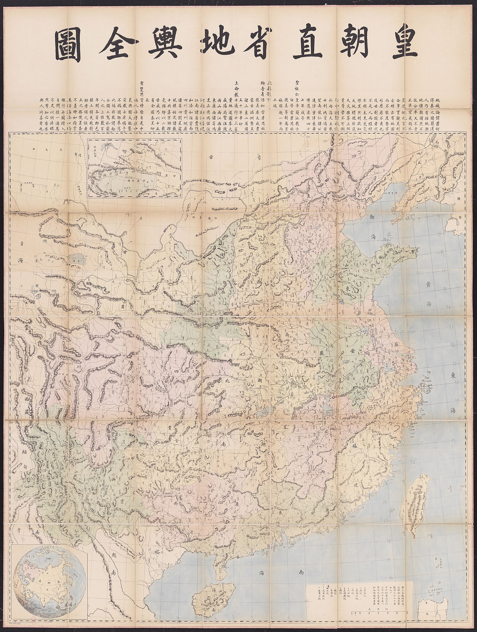
| 中文:皇朝直省地輿全圖,皇朝直省地舆全图,Huángcháo Zhíshěng Dìyú Quántú,Huang-ch'ao Chih-sheng Ti-yü Ch'üan-t'u
English: Complete Map of the Provinces of the Empire ( |
|||||||||||||||||||||||||||
|---|---|---|---|---|---|---|---|---|---|---|---|---|---|---|---|---|---|---|---|---|---|---|---|---|---|---|---|
| Author |
Français : Stanislas Chevalier (1852–1930, père). Éditeur scientifique. |
||||||||||||||||||||||||||
| Title |
中文:皇朝直省地輿全圖,皇朝直省地舆全图,Huángcháo Zhíshěng Dìyú Quántú,Huang-ch'ao Chih-sheng Ti-yü Ch'üan-t'u
English: Complete Map of the Provinces of the Empire |
||||||||||||||||||||||||||
| Description |
Français : Sujet : Divisions politiques et administratives
Chine -- Divisions politiques et administratives Gansu, Province de Xinjiang Uygur Zizhiqu (région autonome) Corée, Péninsule de Mongolie Laos Viêt Nam Luçon, Île de Échelle(s) : [1 : 2 200 000 environ] Appartient à l’ensemble documentaire : PFceChi Appartient à l’ensemble documentaire : RfnEns0 Appartient à l’ensemble documentaire : RfnAsi1 Appartient à l’ensemble documentaire : RfnCoop1 Couverture : Chine Langue : chinois Éditeur : [s.n.] |
||||||||||||||||||||||||||
| Date | between 1850 and 1900 | ||||||||||||||||||||||||||
| Dimensions | height: 128 cm (50.3 in); width: 168 cm (66.1 in) | ||||||||||||||||||||||||||
| Collection |
|
||||||||||||||||||||||||||
| References |
Français : Notice du catalogue : http://catalogue.bnf.fr/ark:/12148/cb40606714k |
||||||||||||||||||||||||||
| Source/Photographer |
Français : Bibliothèque nationale de France, département Cartes et plans, GE F CARTE-6692
Bibliothèque nationale de France (2/3) |
||||||||||||||||||||||||||
| Permission (Reusing this file) |
|
||||||||||||||||||||||||||

.jpg&action=edit§ion=1)
.jpg&flash=no)
File history
Click on a date/time to view the file as it appeared at that time.
| Date/Time | Thumbnail | Dimensions | User | Comment | |
|---|---|---|---|---|---|
| current | 15:10, 21 March 2023 | | 15,120 × 20,033 (49.07 MB) | SteinsplitterBot (talk | contribs) | Bot: Image rotated by 90° |
| 02:27, 26 July 2022 |  | 20,033 × 15,131 (46.09 MB) | Gzen92Bot (talk | contribs) | Gallica btv1b52505774d |
You cannot overwrite this file.
File usage on Commons
The following page uses this file:
.jpg)
.jpg&oldid=825824074)