File:Houston Downtown Map.png
Jump to navigation
Jump to search
Size of this preview: 600 × 599 pixels. Other resolutions: 240 × 240 pixels | 481 × 480 pixels | 698 × 697 pixels.
Original file (698 × 697 pixels, file size: 519 KB, MIME type: image/png)
Captions
Captions
Add a one-line explanation of what this file represents
Summary
[edit]
| Description |
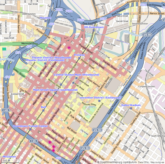
English: This map of Downtown Houston was created from OpenStreetMap project data, collected by the community. The image should remain clear of any additional edits. To annotate the map for an article, use the Infobox or Location Map template and reference the map using map module Houston Downtown. This map may be incomplete, and may contain errors. Submit corrections to the below source link. Do not rely solely on the map for navigation. Steven Driskell
|
| Date | |
| Source | http://www.openstreetmap.org |
| Author | OpenStreetMap contributors |
Licensing
[edit]
This file is licensed under the Creative Commons Attribution-Share Alike 2.5 Generic license.
- You are free:
- to share – to copy, distribute and transmit the work
- to remix – to adapt the work
- Under the following conditions:
- attribution – You must give appropriate credit, provide a link to the license, and indicate if changes were made. You may do so in any reasonable manner, but not in any way that suggests the licensor endorses you or your use.
- share alike – If you remix, transform, or build upon the material, you must distribute your contributions under the same or compatible license as the original.
File history
Click on a date/time to view the file as it appeared at that time.
| Date/Time | Thumbnail | Dimensions | User | Comment | |
|---|---|---|---|---|---|
| current | 22:35, 16 February 2015 | | 698 × 697 (519 KB) | SDriskell (talk | contribs) | User created page with UploadWizard |
You cannot overwrite this file.
File usage on Commons
The following page uses this file:
File usage on other wikis
The following other wikis use this file:
- Usage on ar.wikipedia.org
- Usage on en.wikipedia.org
- Minute Maid Park
- Toyota Center
- Downtown Houston
- Christ Church Cathedral (Houston)
- Wortham Theater Center
- Houston Theater District
- Jones Hall
- The Rice (Houston)
- Club Quarters Hotel (Houston)
- Shell Energy Stadium
- Julia Ideson Building
- The Sam Houston Hotel
- Merchants and Manufacturers Building
- Main Street Market Square Historic District
- United States Customhouse (Houston)
- Annunciation Church (Houston)
- Beaconsfield (Houston)
- Houston Cotton Exchange Building
- Hogg Building
- W. L. Foley Building
- Humble Oil Building
- Union Station (Houston)
- St. Joseph Medical Center (Houston)
- Sweeney, Coombs, and Fredericks Building
- JW Marriott Downtown Houston
- Kennedy Bakery
- McKee Street Bridge
- Pillot Building
- Texas Company Building
- Paul Building
- Palace Hotel (Houston)
- National Biscuit Company Building (Houston)
- S. H. Kress and Co. Building (Houston)
- Houston Post-Dispatch Building
- Scanlan Building
- South Texas National Bank (Houston)
- State National Bank Building (Houston, Texas)
- James Bute Company Warehouse
- City National Bank Building (Houston)
- Module:Location map/data/USA Texas Houston downtown
- San Jacinto Street Bridge over Buffalo Bayou
- Stowers Building
- Arthur B. Cohn House
- 1910 Harris County Courthouse
- Module:Location map/data/USA Texas Houston downtown/doc
- Battelstein's
- Usage on es.wikipedia.org
- Usage on fa.wikipedia.org
View more global usage of this file.