File:Hortense 1996-09-12 1815Z.jpg
Jump to navigation
Jump to search

Size of this preview: 605 × 599 pixels. Other resolutions: 242 × 240 pixels | 485 × 480 pixels | 955 × 946 pixels.
Original file (955 × 946 pixels, file size: 273 KB, MIME type: image/jpeg)
Captions
Captions
Add a one-line explanation of what this file represents
Summary
[edit]
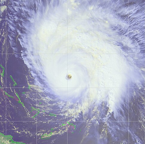
| Description | From NOAA-14 satellite, this image shows Hurricane Hortense on September 12 at 1815 UTC north of the Turks and Caicos Islands. Maximum sustained winds were approximately 135 mph. | |||
| Date | ||||
| Source | http://www.osei.noaa.gov/Events/Tropical/Atlantic/1996/TRChortense255_N4.gif | |||
| Author | NOAA / Operational Significant Event Imagery | |||
| Permission (Reusing this file) |
|
File history
Click on a date/time to view the file as it appeared at that time.
| Date/Time | Thumbnail | Dimensions | User | Comment | |
|---|---|---|---|---|---|
| current | 18:26, 31 October 2006 | | 955 × 946 (273 KB) | Good kitty (talk | contribs) | == Summary == {{Information |Description=From NOAA-14 satellite, this image shows Hurricane Hortense on September 12 at 1815 UTC. Maximum sustained winds were approximately 135 mph. |Source=http://www.osei.noaa.gov/Events/Tropical/Atlantic/1996/TRChortens |
You cannot overwrite this file.
File usage on Commons
The following page uses this file:
- File:Hurricane Hortense 12 sept 1996 1815Z.jpg (file redirect)