File:Horn of Africa 1915.png
Jump to navigation
Jump to search
No higher resolution available.
Horn_of_Africa_1915.png (250 × 299 pixels, file size: 58 KB, MIME type: image/png)
Captions
Captions
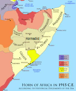
Land occupied by the Dervish around 1915 and Colonial Influences
Summary
[edit]
| Description |
English: Land occupied by the Dervish (1915) and other colonial influences, as well as cities The official Dervish borders were: Northwestern, was at Jidali per the excerpt "nearest dervish post was now at Jidali" (source: MOyse-Bartlett, The King's African Rifles page 421) western, was at Badwein per the excerpt "Badwein at the eastern extremity of the Ain Valley, and thence south-west to the southern border at a point where it is intersected by the 46th degree of longitude. It was our object to confine Dervish activities to their side of this line" (Source: Douglas Jardine, 1923, page 250) southern official boundary was at Damot/Do'mo per excerpt "cattle shall not be permitted to pass beyond the pasturage of the wells enumerated hereafter, they are the wells ... to Damot" (source: Douglas Jardine, 1923, page 158) |
| Date | |
| Source | https://www.pinterest.com/pin/790733647068042943/ |
| Author | Kelly Graham |
Licensing
[edit]
| This file is made available under the Creative Commons CC0 1.0 Universal Public Domain Dedication. | |
| The person who associated a work with this deed has dedicated the work to the public domain by waiving all of their rights to the work worldwide under copyright law, including all related and neighboring rights, to the extent allowed by law. You can copy, modify, distribute and perform the work, even for commercial purposes, all without asking permission.
|
File history
Click on a date/time to view the file as it appeared at that time.
| Date/Time | Thumbnail | Dimensions | User | Comment | |
|---|---|---|---|---|---|
| current | 12:54, 29 May 2023 | | 250 × 299 (58 KB) | Sgottharivuu (talk | contribs) | east |
| 19:24, 28 May 2023 |  | 250 × 299 (58 KB) | Sgottharivuu (talk | contribs) | hormadiid | |
| 18:41, 28 May 2023 |  | 250 × 299 (57 KB) | Sgottharivuu (talk | contribs) | see description for official Dervish map | |
| 00:46, 4 November 2022 |  | 250 × 299 (55 KB) | Somaliyeed (talk | contribs) | Uploaded a work by Kelly Graham from https://www.pinterest.com/pin/790733647068042943/ with UploadWizard |
You cannot overwrite this file.
File usage on Commons
There are no pages that use this file.
File usage on other wikis
The following other wikis use this file:
- Usage on en.wikipedia.org