File:Horizonte gráfico vs Horizonte visible.png
Jump to navigation
Jump to search
Size of this preview: 600 × 600 pixels. Other resolutions: 240 × 240 pixels | 480 × 480 pixels | 768 × 768 pixels | 1,024 × 1,024 pixels | 1,824 × 1,824 pixels.
Original file (1,824 × 1,824 pixels, file size: 6.53 MB, MIME type: image/png)
Captions
Captions
Add a one-line explanation of what this file represents
Summary
[edit]
| Description |
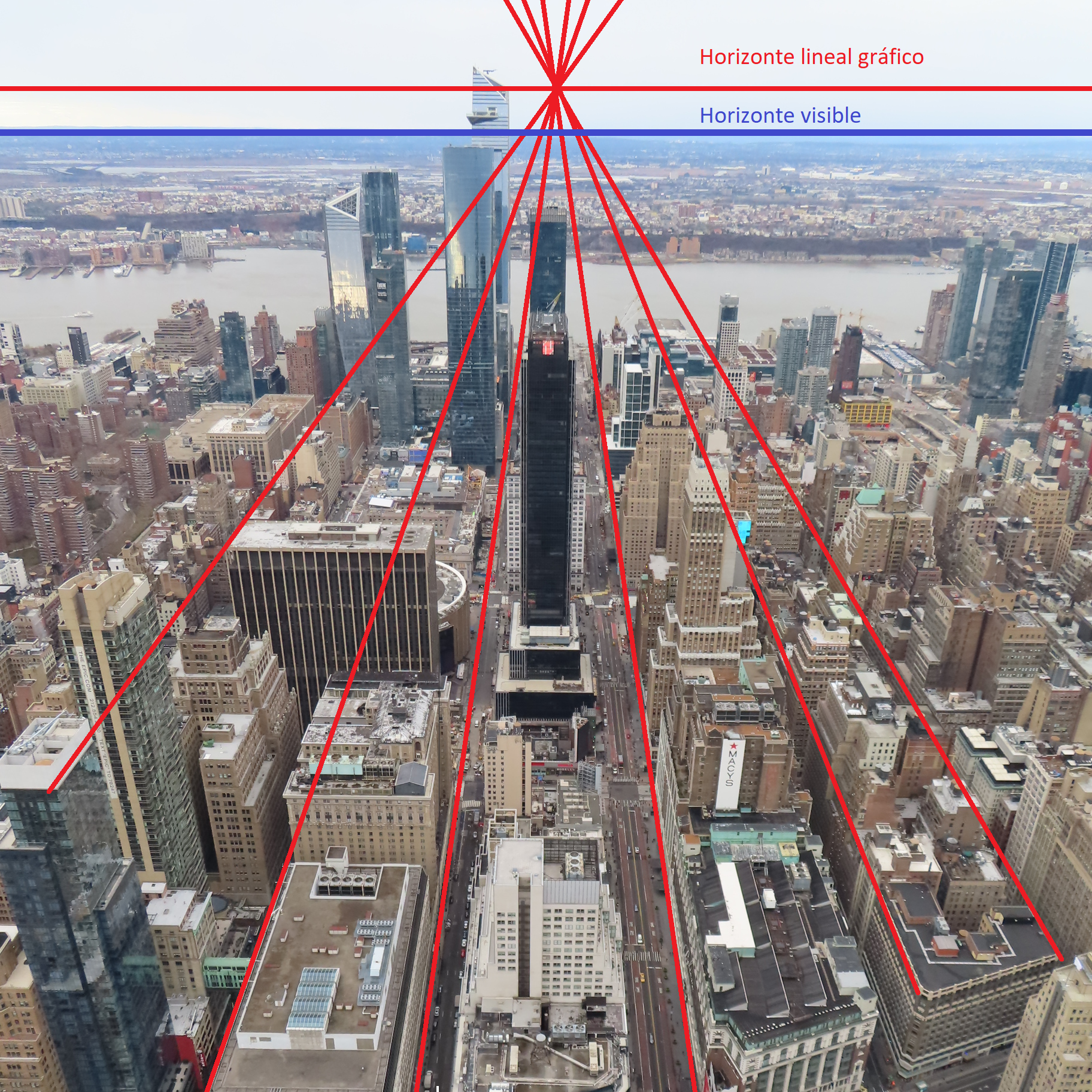
العربية: الاختلافات بين الأفق الرسومي أو الخطي ، حيث تتلاقى الخطوط مع نقطة تلاشي ، والأفق المرئي أو الحقيقي. هذا الأخير أقل من الأول لأن الأرض كروية. Deutsch: Unterschiede zwischen dem grafischen oder linearen Horizont, bei dem die Linien in einem Fluchtpunkt zusammenlaufen, und dem sichtbaren oder realen Horizont. Letzterer liegt unter Ersterem, da die Erde kugelförmig ist. English: Differences between the graphic or linear horizon, in which the lines converge to a vanishing point, and the visible or real horizon. The latter is below the former because the Earth is spherical. Español: Diferencias entre el horizonte gráfico o lineal, en el que convergen las líneas a un punto de fuga, y el horizonte visible o real. Este último se encuetra por debajo del primero debido a que la Tierra es esférica. Français : Différences entre l'horizon graphique ou linéaire, dans lequel les lignes convergent vers un point de fuite, et l'horizon visible ou réel. Ce dernier est en dessous du premier car la Terre est sphérique. Italiano: Differenze tra l'orizzonte grafico o lineare, in cui le linee convergono verso un punto di fuga, e l'orizzonte visibile o reale. Quest'ultimo è al di sotto del primo perché la Terra è sferica. Português: Diferenças entre o horizonte gráfico ou linear, em que as linhas convergem para um ponto de fuga, e o horizonte visível ou real. O último está abaixo do primeiro porque a Terra é esférica. Русский: Различия между графическим или линейным горизонтом, в котором линии сходятся к точке схода, и видимым или реальным горизонтом. Последнее ниже первого, потому что Земля сферическая. 中文:图形或线性地平线(其中线条会聚到一个消失点)与可见或真实地平线之间的差异。 后者低于前者,因为地球是球形的。 |
| Date | |
| Source | File:EmpireStateBuilding202086thFloorExteriorWestSideLookingWestFromEdge.jpg |
| Author | DanielPenfield |
Licensing
[edit]
This file is licensed under the Creative Commons Attribution-Share Alike 4.0 International license.
- You are free:
- to share – to copy, distribute and transmit the work
- to remix – to adapt the work
- Under the following conditions:
- attribution – You must give appropriate credit, provide a link to the license, and indicate if changes were made. You may do so in any reasonable manner, but not in any way that suggests the licensor endorses you or your use.
- share alike – If you remix, transform, or build upon the material, you must distribute your contributions under the same or compatible license as the original.
File history
Click on a date/time to view the file as it appeared at that time.
| Date/Time | Thumbnail | Dimensions | User | Comment | |
|---|---|---|---|---|---|
| current | 16:32, 28 May 2023 | | 1,824 × 1,824 (6.53 MB) | Artistosteles (talk | contribs) | Uploaded a work by DanielPenfield from https://commons.wikimedia.org/wiki/File:EmpireStateBuilding202086thFloorExteriorSouthSideLookingSouthFromEdge.jpg with UploadWizard |
You cannot overwrite this file.
File usage on Commons
There are no pages that use this file.
File usage on other wikis
The following other wikis use this file:
- Usage on es.wikipedia.org