File:Hopper1.jpg
Jump to navigation
Jump to search
No higher resolution available.
Hopper1.jpg (640 × 427 pixels, file size: 130 KB, MIME type: image/jpeg)
Captions
Captions
Add a one-line explanation of what this file represents
| Description |
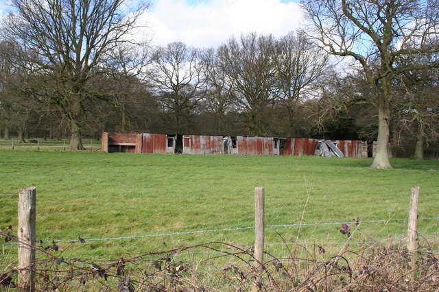
English: Hoppers' huts, Grange Farm, near Tonbridge, Kent, England.
These derelict iron structures are the remains of hoppers' huts, which were used, many years ago, as living accommodation by hop pickers from London who had travelled down to Kent to earn a little money picking the hop harvest. Apparently there are very few similar survivors of these huts. |
| Date | |
| Source | From geograph.org.uk |
| Author | Dr Neil Clifton |
| Permission (Reusing this file) |
Creative Commons Attribution Share-alike license 2.0 |
| Camera location | | View this and other nearby images on: OpenStreetMap |
|---|

|
This image was taken from the Geograph project collection. See this photograph's page on the Geograph website for the photographer's contact details. The copyright on this image is owned by Dr Neil Clifton and is licensed for reuse under the Creative Commons Attribution-ShareAlike 2.0 license.
|
This file is licensed under the Creative Commons Attribution-Share Alike 2.0 Generic license.
Attribution: Dr Neil Clifton
- You are free:
- to share – to copy, distribute and transmit the work
- to remix – to adapt the work
- Under the following conditions:
- attribution – You must give appropriate credit, provide a link to the license, and indicate if changes were made. You may do so in any reasonable manner, but not in any way that suggests the licensor endorses you or your use.
- share alike – If you remix, transform, or build upon the material, you must distribute your contributions under the same or compatible license as the original.
Original upload log
[edit]
The original description page was here. All following user names refer to en.wikipedia.
- 2007-12-17 21:01 Mjroots 640×427× (132972 bytes) Hopper Huts as Grange Farm, Tonbridge {{geograph|351513|Dr Neil Clifton}}
File history
Click on a date/time to view the file as it appeared at that time.
| Date/Time | Thumbnail | Dimensions | User | Comment | |
|---|---|---|---|---|---|
| current | 10:54, 27 November 2008 | | 640 × 427 (130 KB) | Angusmclellan (talk | contribs) | {{Information |Description={{en|Hoppers' huts, Grange Farm, near Tonbridge, Kent, England. These derelict iron structures are the remains of hoppers' huts, which were used, many years ago, as living accommodation by hop pickers from London who had travell |
You cannot overwrite this file.
File usage on Commons
There are no pages that use this file.
File usage on other wikis
The following other wikis use this file:
- Usage on en.wikipedia.org