File:Honter Universalis Cosmographia 1546 UTA.jpg
Jump to navigation
Jump to search

Size of this preview: 781 × 599 pixels. Other resolutions: 313 × 240 pixels | 626 × 480 pixels | 1,001 × 768 pixels | 1,200 × 921 pixels.
Original file (1,200 × 921 pixels, file size: 333 KB, MIME type: image/jpeg)
Captions
Captions
Add a one-line explanation of what this file represents
Summary
[edit]| Title |
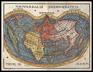
Latina: Universalis Cosmographia |
||||||||||||||||||||||||||||||||||||||||||||||
| Description |
English: This tiny world map dating from 1546 reflects the extraordinary influence of Martin Waldseemüller's now-famous 1507 cordiform (heart-shaped) wall map of the world Universails Cosmographia Secundum Ptholomaei Traditionem et Americi Vespucii Alioru[m] que Lustrationes… in which Waldseemüller first coined the name "America" for a continent. The little map's creator, Johannes Honter (1498-1549) was born in Kronstadt (today Brasov, Romania) and later worked in Vienna, Regensburg, Krakow, Nuremberg, Basel, and Kronstadt, where with his liberal humanist education he became a respected educator, evangelical pastor, town magistrate, and councilor. While in Regensburg, Bavaria, Honter visited nearby Ingolstadt, where he became friends with humanist, mathematician, astronomer, and cartographer Peter Apian (1495-1552), who in 1520 had created the first copy of Waldseemüller's wall map to appear in a book. The original woodcut for Honter's map was made in Zurich (hence the Latin "Tiguri" seen in the bottom left corner by the initials of the map’s engraver Heinrich Vogtherr the Elder) "at great cost" according to the accompanying text of Rudimenta Cosmographica.... |
||||||||||||||||||||||||||||||||||||||||||||||
| Date | |||||||||||||||||||||||||||||||||||||||||||||||
| Source | UTA Libraries Cartographic Connections: map / text | ||||||||||||||||||||||||||||||||||||||||||||||
| Creator |
|
||||||||||||||||||||||||||||||||||||||||||||||
| Credit line |
English: The University of Texas at Arlington Libraries Special Collections |
||||||||||||||||||||||||||||||||||||||||||||||
| Georeferencing | If inappropriate please set warp_status = skip to hide. | ||||||||||||||||||||||||||||||||||||||||||||||
| Bibliographic data | |||||||||||||||||||||||||||||||||||||||||||||||
| Publication |
Rudimenta Cosmographica |
||||||||||||||||||||||||||||||||||||||||||||||
| Author |
|
||||||||||||||||||||||||||||||||||||||||||||||
| Place of publication | Zürich | ||||||||||||||||||||||||||||||||||||||||||||||
| Publisher | |||||||||||||||||||||||||||||||||||||||||||||||
| Archival data | |||||||||||||||||||||||||||||||||||||||||||||||
| Collection |
|
||||||||||||||||||||||||||||||||||||||||||||||
| Dimensions | height: 12 cm (4.7 in); width: 16.2 cm (6.3 in) | ||||||||||||||||||||||||||||||||||||||||||||||
| Medium | hand-colored engraving on paper | ||||||||||||||||||||||||||||||||||||||||||||||
| artwork-references |
Shirley, Rodney W. (1984) The Mapping of the World: Early Printed World Maps 1472-1700, London: The Holland Press, no. 86 , pp. 97–98 |
||||||||||||||||||||||||||||||||||||||||||||||


Licensing
[edit]

|
This file was provided to Wikimedia Commons by the University of Texas at Arlington Libraries as part of a cooperation project. The University of Texas at Arlington Libraries is part of the University of Texas at Arlington, a public research university located in Arlington, Texas.
|
|
The author died in 1556, so this work is in the public domain in its country of origin and other countries and areas where the copyright term is the author's life plus 100 years or fewer. This work is in the public domain in the United States because it was published (or registered with the U.S. Copyright Office) before January 1, 1929. | |
| This file has been identified as being free of known restrictions under copyright law, including all related and neighboring rights. | |
File history
Click on a date/time to view the file as it appeared at that time.
| Date/Time | Thumbnail | Dimensions | User | Comment | |
|---|---|---|---|---|---|
| current | 05:28, 21 May 2019 | | 1,200 × 921 (333 KB) | Michael Barera (talk | contribs) | == {{int:filedesc}} == {{Map |title = ''Universalis Cosmographia'' |description = {{en|This tiny world map dating from 1546 reflects the extraordinary influence of Martin Waldseemüller's now-famous 1507 cordiform (heart-shaped) wall map of the world ''Universails Cosmographia Secundum Ptholomaei Traditionem et Americi Vespucii Alioru[m] que Lustrationes''… in which Waldseemüller first coined the name "America" for a continent. The little map's creator, Johannes Honter (14... |
You cannot overwrite this file.
File usage on Commons
There are no pages that use this file.
File usage on other wikis
The following other wikis use this file:
- Usage on de.wikipedia.org
- Usage on en.wikipedia.org
- Usage on es.wikipedia.org
- Usage on la.wikipedia.org
- Usage on pl.wikipedia.org
- Usage on pt.wikipedia.org