File:Home on the range - panoramio (2).jpg
Jump to navigation
Jump to search

Size of this preview: 800 × 450 pixels. Other resolutions: 320 × 180 pixels | 640 × 360 pixels | 1,024 × 576 pixels | 1,280 × 720 pixels | 2,000 × 1,125 pixels.
Original file (2,000 × 1,125 pixels, file size: 298 KB, MIME type: image/jpeg)
Captions
Captions
Add a one-line explanation of what this file represents
Summary
[edit].jpg&action=edit§ion=1)
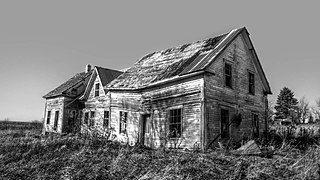
| Description | Home on the range | ||
| Date | Taken on 1 November 2013 | ||
| Source | https://web.archive.org/web/20161030114843/http://www.panoramio.com/photo/99322780 | ||
| Author | Mario Hains | ||
| Permission (Reusing this file) |
This file is licensed under the Creative Commons Attribution-Share Alike 3.0 Unported license. Attribution: Mario Hains
|
||
| Tags (from Panoramio photo page) | Bury, 2013, Abandoned, Abandoned houses, Abandonnés, Ancestors, Ancetres Ancestors, Ancien, Ancien temps, Anciennes maisons, Anciens lieux, Bury, Canada, Effet de lumières, Espace -Temps, Expérimental, hdr, High Key, Lieux abandonnés, Lieux mystérieux, Light, Lights effect, Lumière , Lumière du matin, Maisons abandonnées, Memories, Morning light, Mystic places, Mémoire, Noir et blanc, Nostalgia, November, Novembre, Old, Old Ancestors, Old buildings, Old houses, Québec, Souvenirs, Space-Time |
| Camera location | | View this and other nearby images on: OpenStreetMap |
|---|
.jpg¶ms=045.499331_N_-071.366029_E_globe:Earth_type:camera_source:Panoramio_&language=en)
File history
Click on a date/time to view the file as it appeared at that time.
| Date/Time | Thumbnail | Dimensions | User | Comment | |
|---|---|---|---|---|---|
| current | 12:03, 2 April 2017 | | 2,000 × 1,125 (298 KB) | Panoramio upload bot (talk | contribs) | == {{int:filedesc}} == {{Information |description=Home on the range |date={{Taken on|2013-11-01}} |source=http://www.panoramio.com/photo/99322780 |author=[http://www.panoramio.com/user/1320307?with_photo_id=99322780 Mario Hains] |permission={{cc-by-sa-... |
You cannot overwrite this file.
File usage on Commons
There are no pages that use this file.
.jpg&oldid=650978842)