File:Holy Redeemer Catholic Church, Johnson Street, Mansion Hill, Madison, WI - 52752671253.jpg
Jump to navigation
Jump to search

Size of this preview: 449 × 599 pixels. Other resolutions: 180 × 240 pixels | 360 × 480 pixels | 576 × 768 pixels | 768 × 1,024 pixels | 1,536 × 2,048 pixels | 2,915 × 3,887 pixels.
Original file (2,915 × 3,887 pixels, file size: 3.38 MB, MIME type: image/jpeg)
Captions
Captions
Add a one-line explanation of what this file represents
Summary
[edit]
| Description |
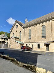
English: Built in 1864-1869, this Romanesque Revival-style church was designed by John Nader for the congregation of the Holy Redeemer Catholic Church. The church was once the second oldest Catholic Church in Madison, and was the second parish organized in the city, being established by German Catholics in 1857, and initially located in a smaller building on the same site. The building was built in the latin cross plan, and is clad in sandstone with a gabled roof with side gables towards the rear at the transepts, a centrally-placed bell tower with a wooden belfry featuring arched louvers, bracketed eaves, arched dormers with clock faces, a slate shingle-clad spire topped by a finial and cross, pilasters at the corners of the building, roman arched stained glass windows and door transoms, small rose windows on the tower below the belfry and on the gable ends of the transepts, six-over-six double-hung windows on the first floor, a cupola at the crossing between the nave and transepts, and a rear apse with beveled corners. The stained glass windows, belfry, and steeple were added as the congregation continued to grow in size and wealth, and in 1892, a parochial school was built southwest of the original church. The church today is the oldest remaining Catholic Church in Madison, following the destruction of St. Raphael's Cathedral due to arson in 2005. The church is a contributing structure in the Mansion Hill Historic District, listed on the National Register of Historic Places in 1997. |
| Date | |
| Source | https://www.flickr.com/photos/59081381@N03/52752671253/ |
| Author | w_lemay |
| Camera location | | View this and other nearby images on: OpenStreetMap |
|---|
Licensing
[edit]
This file is licensed under the Creative Commons Attribution-Share Alike 2.0 Generic license.
- You are free:
- to share – to copy, distribute and transmit the work
- to remix – to adapt the work
- Under the following conditions:
- attribution – You must give appropriate credit, provide a link to the license, and indicate if changes were made. You may do so in any reasonable manner, but not in any way that suggests the licensor endorses you or your use.
- share alike – If you remix, transform, or build upon the material, you must distribute your contributions under the same or compatible license as the original.
| This image was originally posted to Flickr by w_lemay at https://flickr.com/photos/59081381@N03/52752671253. It was reviewed on 17 March 2023 by FlickreviewR 2 and was confirmed to be licensed under the terms of the cc-by-sa-2.0. |
File history
Click on a date/time to view the file as it appeared at that time.
| Date/Time | Thumbnail | Dimensions | User | Comment | |
|---|---|---|---|---|---|
| current | 18:36, 17 March 2023 | | 2,915 × 3,887 (3.38 MB) | Ser Amantio di Nicolao (talk | contribs) | Uploaded a work by w_lemay from https://www.flickr.com/photos/59081381@N03/52752671253/ with UploadWizard |
You cannot overwrite this file.
File usage on Commons
There are no pages that use this file.