File:Holloway Road Underground station geograph-3896092-by-Ben-Brooksbank.jpg
Jump to navigation
Jump to search

Size of this preview: 800 × 488 pixels. Other resolutions: 320 × 195 pixels | 640 × 390 pixels | 1,024 × 624 pixels | 1,280 × 780 pixels | 2,353 × 1,434 pixels.
Original file (2,353 × 1,434 pixels, file size: 3.13 MB, MIME type: image/jpeg)
Captions
Captions
Add a one-line explanation of what this file represents
Summary
[edit]
| Description |
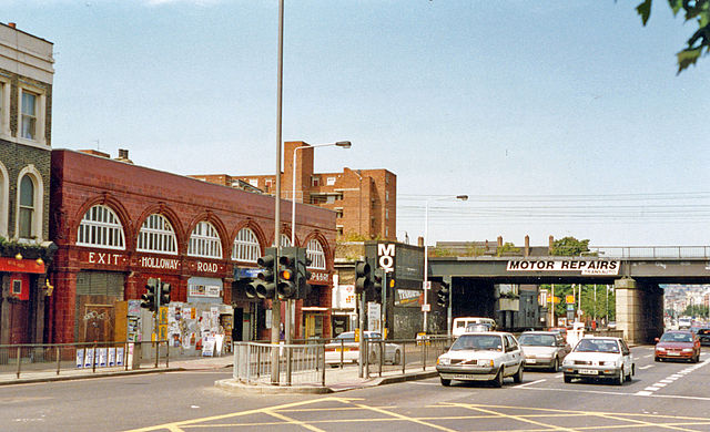
English: Holloway Road, with entrance to London Underground station, 1993. View NW on Holloway Road, near the over-bridge carrying the main lines out of King's Cross station. The Underground station is on the Piccadilly Line, towards Finsbury Park, Arnos Grove and Cockfosters. |
| Date | |
| Source | From geograph.org.uk |
| Author | Ben Brooksbank |
| Permission (Reusing this file) |
Creative Commons Attribution Share-alike license 2.0 |
| Attribution (required by the license) | Ben Brooksbank / Holloway Road, with entrance to London Underground station, 1993 / |
| Camera location | | View this and other nearby images on: OpenStreetMap |
|---|
Licensing
[edit]

|
This image was taken from the Geograph project collection. See this photograph's page on the Geograph website for the photographer's contact details. The copyright on this image is owned by Ben Brooksbank and is licensed for reuse under the Creative Commons Attribution-ShareAlike 2.0 license.
|
This file is licensed under the Creative Commons Attribution-Share Alike 2.0 Generic license.
Attribution: Ben Brooksbank
- You are free:
- to share – to copy, distribute and transmit the work
- to remix – to adapt the work
- Under the following conditions:
- attribution – You must give appropriate credit, provide a link to the license, and indicate if changes were made. You may do so in any reasonable manner, but not in any way that suggests the licensor endorses you or your use.
- share alike – If you remix, transform, or build upon the material, you must distribute your contributions under the same or compatible license as the original.
File history
Click on a date/time to view the file as it appeared at that time.
| Date/Time | Thumbnail | Dimensions | User | Comment | |
|---|---|---|---|---|---|
| current | 08:45, 27 April 2014 | | 2,353 × 1,434 (3.13 MB) | Chevin (talk | contribs) | == {{int:filedesc}} == {{Information |Description={{en|1='''Holloway Road, with entrance to London Underground station, 1993.'''<br/> View NW on Holloway Road, near the over-bridge carrying the main lines out of King's Cross station. The Underground st... |
You cannot overwrite this file.
File usage on Commons
The following page uses this file:
File usage on other wikis
The following other wikis use this file:
- Usage on nl.wikipedia.org