File:HollersbacherFeuchtwiesen 01.jpg
Jump to navigation
Jump to search

Size of this preview: 794 × 600 pixels. Other resolutions: 318 × 240 pixels | 635 × 480 pixels | 1,017 × 768 pixels | 1,280 × 967 pixels | 2,560 × 1,934 pixels | 4,350 × 3,287 pixels.
Original file (4,350 × 3,287 pixels, file size: 7.12 MB, MIME type: image/jpeg)
Captions
Captions
Add a one-line explanation of what this file represents
Summary
[edit]| Description |
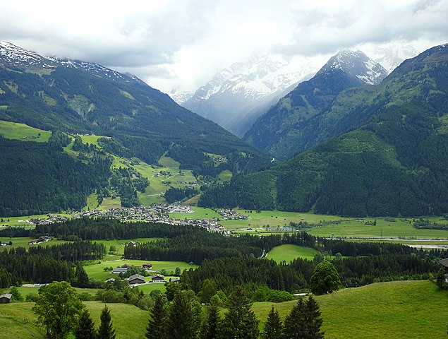
Deutsch: Die Hollersbacher Feuchtwiesen liegen westlich von Hollersbach auf rund 800 Metern Seehöhe. Das Schutzgebiet umfasst Großseggen-, Hochstauden-, Flachmoor- und Pfeifengrasanteile. Bedeutend ist das Areal vor allem für seinen Orchideenreichtum mit Vorkommen des Breitblättrigen Knabenkrauts (Dactylorhiza majalis) und der Echten Sumpfwurz (Epipactis palustris). Zudem ist das Gebiet als Brut- und Durchzugsgebiet für Vögel von Bedeutung. Die Aufnahme wurde von der Paß-Thurn-Straße, Standort Hohe Brücke, gemacht. Dieses Bild bietet einen Überblick. Links der Ort Hollersbach, im Bildhintergrund das Hollersbachtal, im rechten Bilddrittel die Hollersbacher Feuchtwiesen, die sich vom Badesee bis zum bewaldeten Hangfuß erstrecken. |
||
| Date | |||
| Source | Own work | ||
| Author | Wald1siedel | ||
| Permission (Reusing this file) |
|


| Camera location | | View this and other nearby images on: OpenStreetMap |
|---|
Licensing
[edit]
I, the copyright holder of this work, hereby publish it under the following license:
This file is licensed under the Creative Commons Attribution-Share Alike 4.0 International license.
- You are free:
- to share – to copy, distribute and transmit the work
- to remix – to adapt the work
- Under the following conditions:
- attribution – You must give appropriate credit, provide a link to the license, and indicate if changes were made. You may do so in any reasonable manner, but not in any way that suggests the licensor endorses you or your use.
- share alike – If you remix, transform, or build upon the material, you must distribute your contributions under the same or compatible license as the original.
File history
Click on a date/time to view the file as it appeared at that time.
| Date/Time | Thumbnail | Dimensions | User | Comment | |
|---|---|---|---|---|---|
| current | 16:04, 5 June 2016 | | 4,350 × 3,287 (7.12 MB) | Wald1siedel (talk | contribs) | User created page with UploadWizard |
You cannot overwrite this file.
File usage on Commons
The following 2 pages use this file:
File usage on other wikis
The following other wikis use this file:
- Usage on it.wikipedia.org