File:Hochwasser in den Rheinauen bei Duisburg-Baerl am 8.Januar 2012 - panoramio.jpg
Jump to navigation
Jump to search

Size of this preview: 800 × 106 pixels. Other resolutions: 320 × 42 pixels | 640 × 85 pixels | 1,024 × 136 pixels | 1,280 × 169 pixels | 12,053 × 1,596 pixels.
Original file (12,053 × 1,596 pixels, file size: 3.04 MB, MIME type: image/jpeg)
Captions
Captions
Add a one-line explanation of what this file represents
Summary
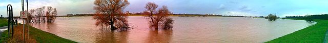
[edit]| Description | Hochwasser in den Rheinauen bei Duisburg-Baerl am 8.Januar 2012 | ||
| Date | Taken on 8 January 2012 | ||
| Source | https://web.archive.org/web/20161024000404/http://www.panoramio.com/photo/64705948 | ||
| Author | giggel | ||
| Permission (Reusing this file) |
This file is licensed under the Creative Commons Attribution 3.0 Unported license. Attribution: giggel
|
||
| Tags (from Panoramio photo page) | Duisburg, Duisburg, Natur pur an Rhein und Ruhr, Niederrhein, Panorama-Fotos ICE, Ruhrauen |
| Camera location | | View this and other nearby images on: OpenStreetMap |
|---|

File history
Click on a date/time to view the file as it appeared at that time.
| Date/Time | Thumbnail | Dimensions | User | Comment | |
|---|---|---|---|---|---|
| current | 14:09, 23 December 2016 | 12,053 × 1,596 (3.04 MB) | Panoramio upload bot (talk | contribs) | == {{int:filedesc}} == {{Information |description=Hochwasser in den Rheinauen bei Duisburg-Baerl am 8.Januar 2012 |date={{Taken on|2012-01-08}} |source=http://www.panoramio.com/photo/64705948 |author=[http://www.panoramio.com/user/1368505?with_photo_id... |
You cannot overwrite this file.
File usage on Commons
There are no pages that use this file.