File:Hobräcke Formation.jpg
Jump to navigation
Jump to search

Size of this preview: 800 × 403 pixels. Other resolutions: 320 × 161 pixels | 640 × 323 pixels | 1,444 × 728 pixels.
Original file (1,444 × 728 pixels, file size: 2.78 MB, MIME type: image/jpeg)
Captions
Captions
Add a one-line explanation of what this file represents
Summary
[edit]
| Description |
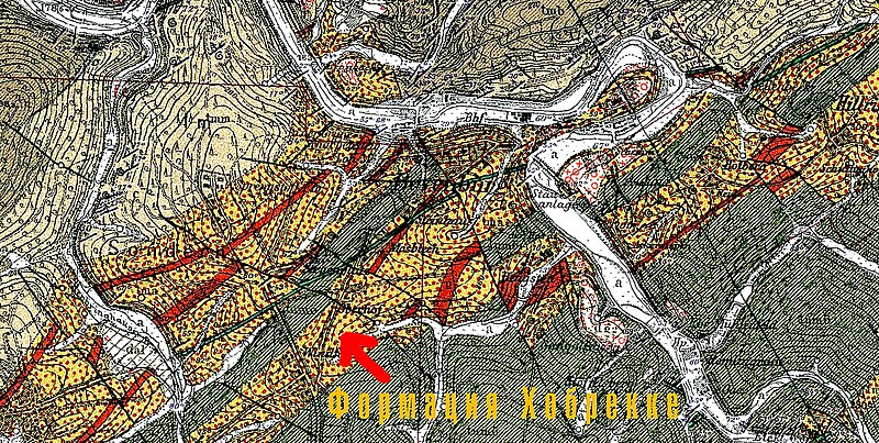
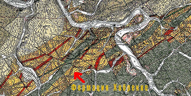
Русский: Геологическая формация Хобрекке (Средний Девон) на реке Вуппер у Байенбурга (Вупперталь). Прусская геологическая карта 1:25 000. Бармен 4709.
English: Geological Formation Hobräcke (Middle Devon) on the Wupper River near Beyenburg (Wuppertal). Prussian geological map 1: 25 000. Barmen 4709.
Deutsch: Geologische Formation Hobräcke (Mittleres Devon) am Wupper bei Beyenburg (Wuppertal). Preußische geologische Karte 1: 25 000. Barmen 4709. |
| Date | |
| Source | Geologische Karte von Preußen und Benachtbarten deutschen Ländern |
| Author | A. Fuchs, W. Paeckel, R. Bärtling |
Licensing
[edit]
|
This work is in the public domain in its country of origin and other countries and areas where the copyright term is the author's life plus 70 years or fewer. | |
| This file has been identified as being free of known restrictions under copyright law, including all related and neighboring rights. | |
File history
Click on a date/time to view the file as it appeared at that time.
| Date/Time | Thumbnail | Dimensions | User | Comment | |
|---|---|---|---|---|---|
| current | 14:05, 7 April 2021 | | 1,444 × 728 (2.78 MB) | Velopilger (talk | contribs) | Uploaded a work by A. Fuchs, W. Paeckel, R. Bärtling from Geologische Karte von Preußen und Benachtbarten deutschen Ländern with UploadWizard |
You cannot overwrite this file.
File usage on Commons
The following page uses this file:
File usage on other wikis
The following other wikis use this file:
- Usage on ru.wikipedia.org
- Usage on www.wikidata.org