File:Hjälmö1.jpg
From Wikimedia Commons, the free media repository
Jump to navigation
Jump to search
Size of this preview: 800 × 344 pixels. Other resolutions: 320 × 138 pixels | 640 × 275 pixels | 1,024 × 440 pixels | 1,280 × 550 pixels | 2,560 × 1,101 pixels | 4,791 × 2,060 pixels.
Original file (4,791 × 2,060 pixels, file size: 3.01 MB, MIME type: image/jpeg)
File information
Structured data
Captions
DescriptionHjälmö1.jpg |
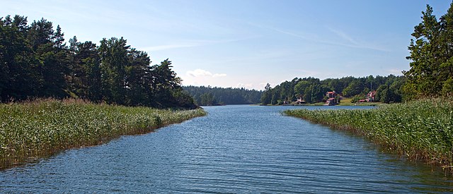
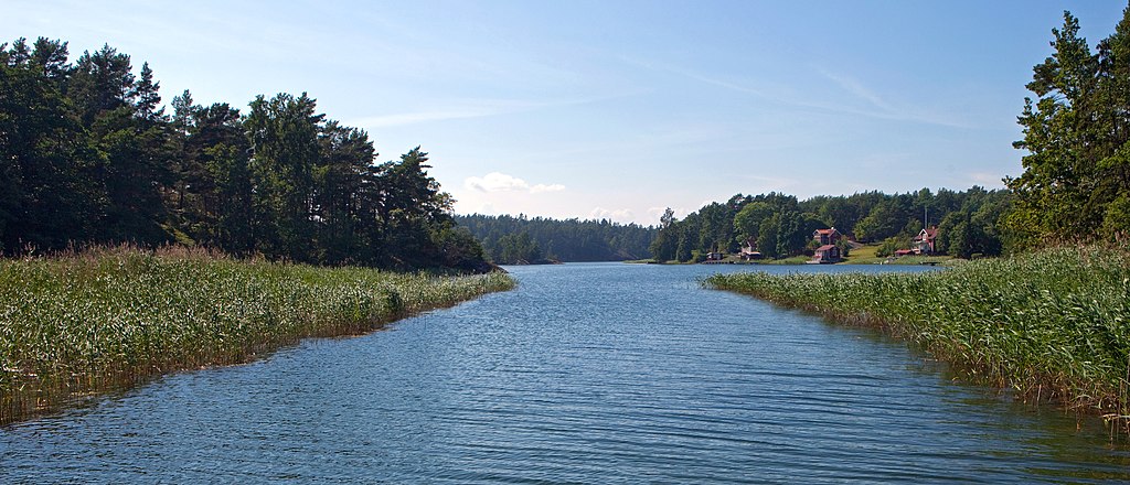
English: Channel between Hjälmö (left) and Gränö (right) in the Stockholm archipelago. |
Date | |
Source | https://www.flickr.com/photos/97469566@N00/5935026904/ |
Author | Bengt E Nyman |
Permission (Reusing this file) |
This file is licensed under the Creative Commons Attribution 2.0 Generic license.
|
Camera location | 59° 25′ 00.1″ N, 18° 41′ 43.9″ E | View this and other nearby images on: OpenStreetMap | 59.416694; 18.695528 |
---|
This image, originally posted to Flickr, was reviewed on 11 December 2011 by the administrator or reviewer Leoboudv, who confirmed that it was available on Flickr under the stated license on that date. |
File history
Click on a date/time to view the file as it appeared at that time.
Date/Time | Thumbnail | Dimensions | User | Comment | |
---|---|---|---|---|---|
current | 16:18, 10 December 2011 | 4,791 × 2,060 (3.01 MB) | Esquilo (talk | contribs) | {{Information |Description ={{sv|1=Sundet mellan Hjälmö (till vänster) och Gränö (till höger) i Stockholms skärgård.}} |Source =http://www.flickr.com/photos/97469566@N00/5935026904/ |Aut |
You cannot overwrite this file.
File usage on Commons
There are no pages that use this file.
File usage on other wikis
The following other wikis use this file:
- Usage on sv.wikipedia.org
Metadata
This file contains additional information such as Exif metadata which may have been added by the digital camera, scanner, or software program used to create or digitize it. If the file has been modified from its original state, some details such as the timestamp may not fully reflect those of the original file. The timestamp is only as accurate as the clock in the camera, and it may be completely wrong.
Camera manufacturer | Canon |
---|---|
Camera model | Canon EOS 5D Mark II |
Exposure time | 1/400 sec (0.0025) |
F-number | f/10 |
ISO speed rating | 100 |
Date and time of data generation | 13:43, 8 July 2011 |
Lens focal length | 28 mm |
Altitude | 4,294,967,293 meters above sea level |
Orientation | Normal |
Horizontal resolution | 240 dpi |
Vertical resolution | 240 dpi |
Software used | GIMP 2.4.2 |
File change date and time | 17:02, 10 December 2011 |
Exposure Program | Normal program |
Exif version | 2.21 |
Date and time of digitizing | 15:43, 8 July 2011 |
APEX shutter speed | 8.643856 |
APEX aperture | 6.643856 |
APEX exposure bias | 0 |
Maximum land aperture | 3 APEX (f/2.83) |
Metering mode | Center weighted average |
Flash | Flash did not fire, compulsory flash suppression |
DateTime subseconds | 67 |
DateTimeDigitized subseconds | 67 |
Color space | sRGB |
Focal plane X resolution | 3,849.2117888965 |
Focal plane Y resolution | 3,908.1419624217 |
Focal plane resolution unit | inches |
Custom image processing | Normal process |
Exposure mode | Auto exposure |
White balance | Auto white balance |
Scene capture type | Standard |
GPS tag version | 0.0.0.2 |
GPS date | 13:43, 8 July 2011 |
Receiver status | Measurement in progress |
Geodetic survey data used | WGS-84 |
Image height | 2,060 px |
Image width | 4,791 px |
Serial number of camera | 320210318 |
Lens used | EF24-70mm f/2.8L USM |
Rating (out of 5) | 1 |
Date metadata was last modified | 22:04, 13 July 2011 |
Unique ID of original document | xmp.did:83201F0BD1ABE0118F2C8CDBE36E941F |