File:Historischer Grenzstein am Rande des Grevenhoops, Gemeinde Gödenstorf, Landkreis Harburg, Niedersachsen, ein sog. Georg-Rex-Stein - 03.09.2017.jpg
![File:Historischer Grenzstein am Rande des Grevenhoops, Gemeinde Gödenstorf, Landkreis Harburg, Niedersachsen, ein sog. Georg-Rex-Stein - 03.09.2017.jpg](https://upload.wikimedia.org/wikipedia/commons/thumb/8/89/Historischer_Grenzstein_am_Rande_des_Grevenhoops%2C_Gemeinde_G%C3%B6denstorf%2C_Landkreis_Harburg%2C_Niedersachsen%2C_ein_sog._Georg-Rex-Stein_-_03.09.2017.jpg/400px-Historischer_Grenzstein_am_Rande_des_Grevenhoops%2C_Gemeinde_G%C3%B6denstorf%2C_Landkreis_Harburg%2C_Niedersachsen%2C_ein_sog._Georg-Rex-Stein_-_03.09.2017.jpg?20170912200325)
Original file (4,000 × 6,000 pixels, file size: 19.66 MB, MIME type: image/jpeg)
Captions
Captions
Summary
[edit]DescriptionHistorischer Grenzstein am Rande des Grevenhoops, Gemeinde Gödenstorf, Landkreis Harburg, Niedersachsen, ein sog. Georg-Rex-Stein - 03.09.2017.jpg |
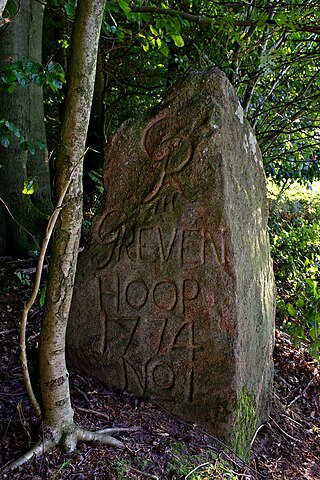
Deutsch: Historischer Grenzstein am nördlichen Rand des Waldgebietes Grevenhoop (Verwaltung heute: Klosterrevierförsterei Garlstorfer Wald) auf dem Gebiet der Gemeinde Gödenstorf in der Samtgemeinde Salzhausen (Niedersachsen, Landkreis Harburg): ein sogenannter Georg-Rex-Stein mit dem Monogramm von Georg III. in seiner Eigenschaft als Kurfürst des Kurfürstentums Braunschweig-Lüneburg zur Kennzeichnung der Grenze des herrschaftlichen Waldes im 18. Jahrhundert. Neben dem Monogramm kennzeichnet auch die Nummer Eins den Stein als Anfang dieser versteinten Grenze, die vermutlich per Rezess im Jahre 1774 mit den Waldinteressenten (Bauern) ausgehandelt worden ist.
|
||
Date | |||
Source | Own work | ||
Author | Wolfgang Lemke / Landmensch 2 |
Object location | 53° 11′ 50.52″ N, 10° 07′ 05.8″ E ![]() | View this and other nearby images on: OpenStreetMap | ![]() |
---|
Licensing
[edit]![w:en:Creative Commons](https://upload.wikimedia.org/wikipedia/commons/thumb/7/79/CC_some_rights_reserved.svg/90px-CC_some_rights_reserved.svg.png)
![attribution](https://upload.wikimedia.org/wikipedia/commons/thumb/1/11/Cc-by_new_white.svg/24px-Cc-by_new_white.svg.png)
![share alike](https://upload.wikimedia.org/wikipedia/commons/thumb/d/df/Cc-sa_white.svg/24px-Cc-sa_white.svg.png)
- You are free:
- to share – to copy, distribute and transmit the work
- to remix – to adapt the work
- Under the following conditions:
- attribution – You must give appropriate credit, provide a link to the license, and indicate if changes were made. You may do so in any reasonable manner, but not in any way that suggests the licensor endorses you or your use.
- share alike – If you remix, transform, or build upon the material, you must distribute your contributions under the same or compatible license as the original.
![]() |
This image was uploaded as part of Wiki Loves Monuments 2017.
Afrikaans ∙ Alemannisch ∙ azərbaycanca ∙ Bahasa Indonesia ∙ Bahasa Melayu ∙ Bikol Central ∙ bosanski ∙ brezhoneg ∙ català ∙ čeština ∙ Cymraeg ∙ dansk ∙ davvisámegiella ∙ Deutsch ∙ eesti ∙ English ∙ español ∙ Esperanto ∙ euskara ∙ français ∙ Frysk ∙ Gaeilge ∙ galego ∙ hrvatski ∙ Ido ∙ italiano ∙ latviešu ∙ Lëtzebuergesch ∙ Malagasy ∙ magyar ∙ Malti ∙ Nederlands ∙ norsk ∙ norsk nynorsk ∙ norsk bokmål ∙ polski ∙ português ∙ português do Brasil ∙ română ∙ shqip ∙ sicilianu ∙ slovenčina ∙ slovenščina ∙ suomi ∙ svenska ∙ Tagalog ∙ Türkçe ∙ Yorùbá ∙ Zazaki ∙ Ελληνικά ∙ беларуская ∙ беларуская (тарашкевіца) ∙ български ∙ кыргызча ∙ македонски ∙ русский ∙ српски / srpski ∙ українська ∙ ქართული ∙ հայերեն ∙ नेपाली ∙ हिन्दी ∙ বাংলা ∙ മലയാളം ∙ ไทย ∙ 한국어 ∙ +/− |
![]() |
File history
Click on a date/time to view the file as it appeared at that time.
Date/Time | Thumbnail | Dimensions | User | Comment | |
---|---|---|---|---|---|
current | 20:03, 12 September 2017 | ![]() | 4,000 × 6,000 (19.66 MB) | Landmensch 2 (talk | contribs) | User created page with UploadWizard |
You cannot overwrite this file.
File usage on Commons
The following 2 pages use this file:
Metadata
This file contains additional information such as Exif metadata which may have been added by the digital camera, scanner, or software program used to create or digitize it. If the file has been modified from its original state, some details such as the timestamp may not fully reflect those of the original file. The timestamp is only as accurate as the clock in the camera, and it may be completely wrong.
Camera manufacturer | RICOH IMAGING COMPANY, LTD. |
---|---|
Camera model | PENTAX K-70 |
Exposure time | 1/13 sec (0.076923076923077) |
F-number | f/9 |
ISO speed rating | 200 |
Date and time of data generation | 18:43, 3 September 2017 |
Lens focal length | 24 mm |
Width | 4,000 px |
Height | 6,000 px |
Bits per component |
|
Pixel composition | RGB |
Orientation | Normal |
Number of components | 3 |
Horizontal resolution | 300 dpi |
Vertical resolution | 300 dpi |
Software used | Adobe Photoshop Elements 14.0 (Windows) |
File change date and time | 23:40, 11 September 2017 |
Y and C positioning | Co-sited |
Exposure Program | Aperture priority |
Exif version | 2.3 |
Date and time of digitizing | 18:43, 3 September 2017 |
Meaning of each component |
|
APEX shutter speed | 3.70044 |
APEX aperture | 6.33985 |
APEX exposure bias | −1.3 |
Metering mode | Pattern |
Flash | Flash did not fire, compulsory flash suppression |
Supported Flashpix version | 1 |
Color space | sRGB |
Sensing method | One-chip color area sensor |
File source | Digital still camera |
Scene type | A directly photographed image |
Custom image processing | Normal process |
Exposure mode | Auto bracket |
White balance | Auto white balance |
Focal length in 35 mm film | 36 mm |
Scene capture type | Standard |
Contrast | Hard |
Saturation | Normal |
Sharpness | Hard |
Subject distance range | Close view |
GPS tag version | 0.0.3.2 |
Lens used | HD PENTAX-DA L 18-50mm F4-5.6 DC WR RE |
Date metadata was last modified | 01:40, 12 September 2017 |
Unique ID of original document | AB5888FC12CA1755601AEF15245C9F9C |
IIM version | 32,767 |
Structured data
Items portrayed in this file
depicts
some value
3 September 2017
53°11'50.518"N, 10°7'5.797"E
- Cultural heritage monuments in Lower Saxony with known IDs
- Files with coordinates missing SDC location of creation (53° N, 10° E)
- CC-BY-SA-4.0
- Self-published work
- Images from Wiki Loves Monuments 2017
- Images from Wiki Loves Monuments 2017 in Germany
- Images from Wiki Loves Monuments missing SDC depicts
- Images from Wiki Loves Monuments missing SDC location of creation
- Images from Wiki Loves Monuments 2017, DE-NI
- Uploaded via Campaign:wlm-de-ni
- Taken with Pentax K-70
- Files by User:Landmensch 2