File:Historic heritage sites of Jharkhand with GPS coordinates.jpg
Original file (2,158 × 2,510 pixels, file size: 1.08 MB, MIME type: image/jpeg)
Captions
Captions
Summary
[edit]
| Description |
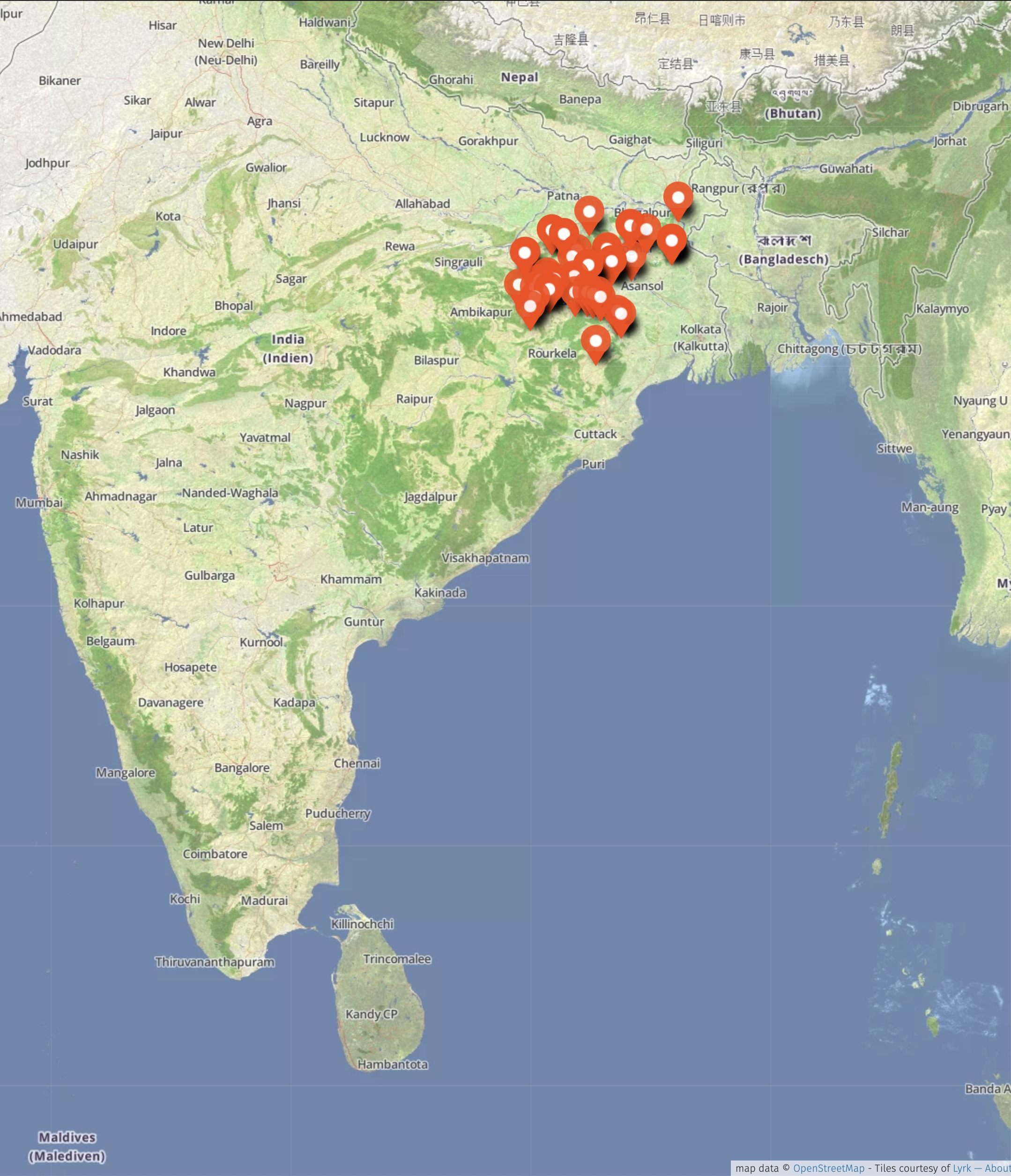
English: Jharkhand is a small eastern state of India, created from the southern part of previously larger state of Bihar. Hilly and more forested, it has numerous Buddhist and Hindu historic sites like Bihar. It also hosts some important Jaina sites.
The map above shows over 40 historic sites in Jharkhand with GPS coordinates. The GPS coordinates are based on field surveys and periodic site visits since 2019. Ancient tank and temple remains, Benisagar 21°59′06″N 85°53′26″E / 21.98505°N 85.890479°E Ruam mud fort, Royam 22°37′44″N 86°23′11″E / 22.62889°N 86.386374°E Joi Da Temple, Kurli 22°56′43″N 86°00′32″E / 22.94527°N 86.008751°E Maa Dewri Mandir 23°02′46″N 85°40′58″E / 23.046134°N 85.682887°E Durga and other temples, Haradih 23°08′48″N 85°41′40″E / 23.14655°N 85.694314°E Dombari Buru 23°02′25″N 85°24′43″E / 23.04029°N 85.411916°E Shiva stone temple, Khekparta 23°27′10″N 84°44′49″E / 23.45284°N 84.746984°E Navratna Garh Fort, Asi writes 23°06′36″N 84°47′01″E / 23.10994°N 84.783719°E Rani Lukvar (Navratn Garh) 23°06′38″N 84°47′05″E / 23.11061°N 84.784689°E Akhilesharwar Dham, Kaspur 23°22′29″N 84°47′42″E / 23.37464°N 84.794942°E Happa Muni Mahamaya temple 23°18′24″N 84°34′52″E / 23.30676°N 84.581193°E Malooti Mouliksha Mandir, Maluti 24°09′19″N 87°40′30″E / 24.155271°N 87.675099°E Temple complex - Rajbari 24°09′35″N 87°40′26″E / 24.15985°N 87.673896°E Maluti Shiv Mondir 24°09′32″N 87°40′31″E / 24.15901°N 87.675372°E Singhi Dalan 25°03′21″N 87°50′01″E / 25.055951°N 87.833625°E Tonks of 24 Jain Tirthankaras 23°59′45″N 86°08′49″E / 23.99595°N 86.147034°E Parasnath Hill 23°57′54″N 86°08′41″E / 23.96490°N 86.144649°E Murhar hill fort and monuments, Khukhara 23°19′48″N 84°55′06″E / 23.32989°N 84.918307°E State Museum 23°23′01″N 85°23′08″E / 23.38353°N 85.385467°E Jain rock cut reliefs, Koluha Pahad 24°22′31″N 84°52′02″E / 24.37517°N 84.867308°E Kauleshwari Kali temple, Koluha Hill 24°22′33″N 84°51′52″E / 24.37593°N 84.864437°E Basudeo Kona Shiva Temple 22°55′52″N 84°27′21″E / 22.93099°N 84.455730°E Baba Tanginath Dham Temple, Mahjgaon 23°12′24″N 84°05′14″E / 23.206789°N 84.087229°E Baba Baidyanath Temple, Deoghar 24°29′33″N 86°42′00″E / 24.49247°N 86.699967°E Naulakha Temple, Deoghar 24°28′38″N 86°42′29″E / 24.47712°N 86.708092°E Baba Basukinath Dham, Basukinath 24°23′40″N 87°05′13″E / 24.39441°N 87.086852°E Ghodsimar Dham, Devgarh 24°46′09″N 85°44′23″E / 24.769231°N 85.739739°E Maa Chinmastike mandir 23°37′55″N 85°42′35″E / 23.63197°N 85.709809°E Surya Mandir 23°37′58″N 85°42′34″E / 23.63265°N 85.709542°E Rajrappa Mandir 23°37′56″N 85°42′39″E / 23.63227°N 85.710780°E Palamau Fort (Old) 23°53′38″N 84°14′12″E / 23.89389°N 84.236770°E Palamu New Fort 23°53′42″N 84°13′47″E / 23.89492°N 84.229690°E Bhadrakali Mandir 24°17′34″N 85°08′34″E / 24.29265°N 85.142891°E Sheetalnath Digambar Jain Mandir Itkhori 24°17′40″N 85°08′25″E / 24.29441°N 85.140305°E Buddhist site, Sitagarh hills Bahoranpur 23°57′03″N 85°26′28″E / 23.95077°N 85.441115°E Chechka Dham temples 23°42′18″N 86°15′54″E / 23.70492°N 86.265130°E Chechka Dham site 2 23°42′33″N 86°15′36″E / 23.70906°N 86.260029°E Ghatshila Rankini Mandir 22°34′46″N 86°28′56″E / 22.579541°N 86.482293°E Kapileshwar Dhaam 23°48′05″N 86°43′27″E / 23.80145°N 86.724191°E Isko cave 23°48′25″N 85°19′53″E / 23.80707°N 85.331425°E Anjani dham, Gumla 23°08′22″N 84°27′25″E / 23.13946°N 84.456879°E Ramrekha dham, Kairbera 22°43′37″N 84°21′34″E / 22.72700°N 84.359580°E Ichagarh Palace 23°02′22″N 85°56′07″E / 23.03938°N 85.935266°E Dewaltand Jain Mandir 23°00′31″N 85°49′26″E / 23.00870°N 85.823841°E This map is a derivative work on the open source, creative commons Open Street Map base map. |
|||||||||||||||
| Date | ||||||||||||||||
| Source | Own work | |||||||||||||||
| Author | Ms Sarah Welch | |||||||||||||||
| Permission (Reusing this file) |
|
Licensing
[edit]
- You are free:
- to share – to copy, distribute and transmit the work
- to remix – to adapt the work
- Under the following conditions:
- attribution – You must give appropriate credit, provide a link to the license, and indicate if changes were made. You may do so in any reasonable manner, but not in any way that suggests the licensor endorses you or your use.
- share alike – If you remix, transform, or build upon the material, you must distribute your contributions under the same or compatible license as the original.
File history
Click on a date/time to view the file as it appeared at that time.
| Date/Time | Thumbnail | Dimensions | User | Comment | |
|---|---|---|---|---|---|
| current | 13:47, 21 November 2022 | | 2,158 × 2,510 (1.08 MB) | Ms Sarah Welch (talk | contribs) | Uploaded own work with UploadWizard |
You cannot overwrite this file.
File usage on Commons
There are no pages that use this file.