File:Hinnamnor 2022-09-01 0000Z.jpg
Jump to navigation
Jump to search

Size of this preview: 480 × 600 pixels. Other resolutions: 192 × 240 pixels | 384 × 480 pixels | 614 × 768 pixels | 819 × 1,024 pixels | 1,638 × 2,048 pixels | 3,200 × 4,000 pixels.
Original file (3,200 × 4,000 pixels, file size: 15.46 MB, MIME type: image/jpeg)
Captions
Captions
Add a one-line explanation of what this file represents
Summary
[edit]| Description |
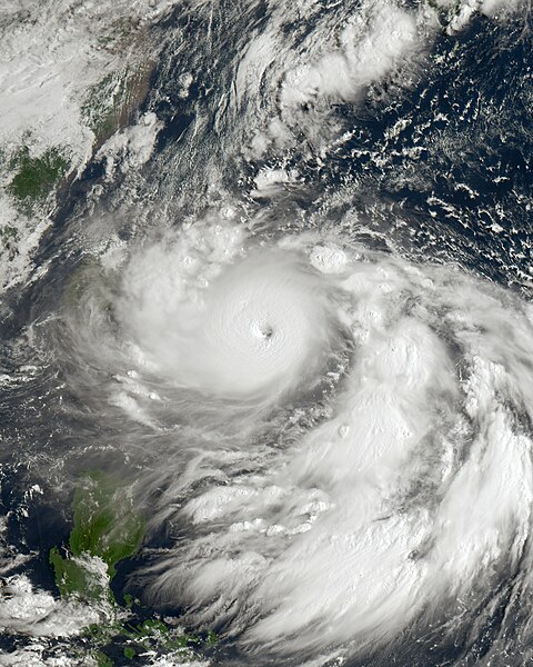
English: This authentic true-color depiction of Typhoon Hinnamnor, locally referred to as "Henry" in the Philippines, was captured on September 1, 2022, at 0:00 UTC (8:00 AM Taiwan Local Time) by the Advanced Himawari Imager (AHI) instrument aboard the JMA's Himawari 8 satellite. Hinnamnor emerged as a compact and formidable typhoon originating from a tropical disturbance northeast of the Marshall Islands during the 2022 Pacific typhoon season in late August. At the time of imaging, Hinnamnor had traversed the Okinawa Islands and positioned itself just east of Taiwan, transitioning into the area of responsibility of PAGASA. Subsequently, it made an impact on the Korean Peninsula, followed by a trajectory towards extratropical conversion, affecting Eastern Russia while traversing the Sea of Japan. During the moment of capture, Hinnamnor had reached its secondary peak intensity, categorized as a Category 5 equivalent typhoon, with wind speeds reaching 160 mph (260 km/h) (140 knots) on the 1-minute Saffir-Simpson scale and 115 mph (185 km/h) on the 10-minute JMA typhoon scale, qualifying it as a "very strong typhoon" by those standards. Additionally, the typhoon exhibited a minimum central pressure of 920 mbar (27.2 inHg) at the time of observation. |
| Date | |
| Source | https://re.ssec.wisc.edu |
| Author | University of Wisconsin-Madison, Space Science and Engineering Center |
Licensing
[edit]This image was produced by the SSEC/CIMSS, University of Wisconsin–Madison. All the images published on their website can be freely used, as long as the source is acknowledged. (disclaimer (archive))
|
 |

File history
Click on a date/time to view the file as it appeared at that time.
| Date/Time | Thumbnail | Dimensions | User | Comment | |
|---|---|---|---|---|---|
| current | 19:44, 20 October 2023 | | 3,200 × 4,000 (15.46 MB) | TheWxResearcher (talk | contribs) | m |
| 19:34, 20 October 2023 |  | 3,200 × 4,000 (15.45 MB) | TheWxResearcher (talk | contribs) | Color correction. | |
| 21:38, 27 May 2023 |  | 2,500 × 3,200 (9.6 MB) | TheWxResearcher (talk | contribs) | Reverted to version as of 16:37, 22 January 2023 (UTC) | |
| 15:04, 25 May 2023 |  | 1,550 × 2,000 (4.36 MB) | Papacyclones (talk | contribs) | Reverted to version as of 02:07, 1 September 2022 (UTC) | |
| 16:37, 22 January 2023 |  | 2,500 × 3,200 (9.6 MB) | TheWxResearcher (talk | contribs) | Cropped, okay definitely the last update not going to touch it anymore. | |
| 16:34, 22 January 2023 |  | 2,700 × 3,200 (10.42 MB) | TheWxResearcher (talk | contribs) | I reprojected this image onto a flat map like worldview so the typhoon won't appear slanted, this will be the last update on this image. | |
| 20:28, 14 December 2022 |  | 2,500 × 3,300 (9.29 MB) | TheWxResearcher (talk | contribs) | m | |
| 19:07, 14 December 2022 |  | 2,500 × 3,300 (8.78 MB) | TheWxResearcher (talk | contribs) | 500m resolution and focused more on the Typhoon | |
| 02:07, 1 September 2022 |  | 1,550 × 2,000 (4.36 MB) | TheWxResearcher (talk | contribs) | Uploaded a work by University of Wisconsin-Madison, Space Science and Engineering Center from https://re.ssec.wisc.edu with UploadWizard |
You cannot overwrite this file.
File usage on Commons
There are no pages that use this file.
File usage on other wikis
The following other wikis use this file:
- Usage on en.wikipedia.org
- Usage on es.wikipedia.org
- Usage on fa.wikipedia.org
- Usage on ja.wikipedia.org
- Usage on ko.wikipedia.org
- Usage on pt.wikipedia.org
- Usage on th.wikipedia.org
- Usage on uk.wikipedia.org
- Usage on vi.wikipedia.org
- Usage on zh.wikipedia.org