File:Hindolvestone railway station - geograph.org.uk - 354371.jpg
Jump to navigation
Jump to search
No higher resolution available.
Hindolvestone_railway_station_-_geograph.org.uk_-_354371.jpg (640 × 480 pixels, file size: 136 KB, MIME type: image/jpeg)
Captions
Captions
Add a one-line explanation of what this file represents
Summary
[edit]
| Description |
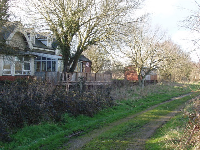
English: Derelict railway station It's hard to imagine that this was one of many small, country railway stations which dotted the countryside of Norfolk. In the late 19th century, there were various lines connecting Norwich with King's Lynn, Cromer, Aylsham, Fakenham and Melton Constable, which was once known as the Crewe of the East. This is a picture of Hindolveston Station now privately owned but badly in need of some attention. The platform is where the railings can be seen and in the background is an old coach, minus its wheels. The line went to Melton and was closed even before the Beeching cuts of the 1960s. |
| Date | |
| Source | From geograph.org.uk; transferred by User:oxyman using geograph_org2commons. |
| Author | David Williams |
| Permission (Reusing this file) |
Creative Commons Attribution Share-alike license 2.0 |
| Camera location | | View this and other nearby images on: OpenStreetMap |
|---|
| Object location | | View this and other nearby images on: OpenStreetMap |
|---|
_region:GB-GBN_heading:315.00&language=en)
Licensing
[edit]

|
This image was taken from the Geograph project collection. See this photograph's page on the Geograph website for the photographer's contact details. The copyright on this image is owned by David Williams and is licensed for reuse under the Creative Commons Attribution-ShareAlike 2.0 license.
|
This file is licensed under the Creative Commons Attribution-Share Alike 2.0 Generic license.
Attribution: David Williams
- You are free:
- to share – to copy, distribute and transmit the work
- to remix – to adapt the work
- Under the following conditions:
- attribution – You must give appropriate credit, provide a link to the license, and indicate if changes were made. You may do so in any reasonable manner, but not in any way that suggests the licensor endorses you or your use.
- share alike – If you remix, transform, or build upon the material, you must distribute your contributions under the same or compatible license as the original.
File history
Click on a date/time to view the file as it appeared at that time.
| Date/Time | Thumbnail | Dimensions | User | Comment | |
|---|---|---|---|---|---|
| current | 01:19, 2 November 2009 | | 640 × 480 (136 KB) | File Upload Bot (Magnus Manske) (talk | contribs) | == Summary == {{Information |Description=Derelict railway station |Source=From [http://www.geograph.org.uk/photo/354371 geograph.org.uk]; transferd by User:oxyman using [http://toolserver.org/~magnus/geograph_org2commons.php geograph_org2commons]. |Da |
You cannot overwrite this file.
File usage on Commons
The following 2 pages use this file:
File usage on other wikis
The following other wikis use this file:
- Usage on en.wikipedia.org
- Usage on www.wikidata.org