File:Hillsboro Inlet aerial view.jpg
Jump to navigation
Jump to search

Size of this preview: 800 × 541 pixels. Other resolutions: 320 × 216 pixels | 640 × 433 pixels | 1,024 × 692 pixels | 1,500 × 1,014 pixels.
Original file (1,500 × 1,014 pixels, file size: 187 KB, MIME type: image/jpeg)
Captions
Captions
Add a one-line explanation of what this file represents
| Description |
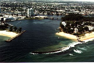
English: Aerial view of Hillsboro Inlet in Pompano Beach, Florida, USA. The inlet connects the Intracoastal Waterway with the Atlantic Ocean. View is from over the Atlantic Ocean, looking inland to the northwest. A section of the Intracoastal Waterway is visible running left–right across the center of the picture.
Coordinates: 26°15′35.15″N 80°4′57.39″W / 26.2597639°N 80.0826083°W |
|||
| Location | Pompano Beach, Florida, USA. | |||
| Date | not specified or unknown | |||
| Source |
U.S. Army Corps of Engineers Digital Visual Library Image page Image description page Digital Visual Library home page |
|||
| Author | Tony Santana, U.S. Army Corps of Engineers | |||
| Permission (Reusing this file) |
|
File history
Click on a date/time to view the file as it appeared at that time.
| Date/Time | Thumbnail | Dimensions | User | Comment | |
|---|---|---|---|---|---|
| current | 23:47, 26 April 2007 | | 1,500 × 1,014 (187 KB) | DanMS (talk | contribs) | {{Information | Description = {{en|Aerial view of Hillsboro Inlet in Pompano Beach, Florida, USA. The inlet connects the Intracoastal Waterway with the Atlantic Ocean. View is from over the Atlantic Ocean, looking inland to the northwest. A section of |
You cannot overwrite this file.
File usage on Commons
There are no pages that use this file.
File usage on other wikis
The following other wikis use this file:
- Usage on ceb.wikipedia.org
- Usage on en.wikipedia.org
- Usage on eo.wikipedia.org
- Usage on ja.wikipedia.org
- Usage on mdf.wikipedia.org
- Usage on uk.wikipedia.org
- Usage on www.wikidata.org