File:Highgate Road Camden Town geograph-3675942-by-Ben-Brooksbank.jpg
Jump to navigation
Jump to search

Size of this preview: 800 × 549 pixels. Other resolutions: 320 × 219 pixels | 640 × 439 pixels | 1,024 × 702 pixels | 1,280 × 878 pixels | 2,281 × 1,564 pixels.
Original file (2,281 × 1,564 pixels, file size: 3.44 MB, MIME type: image/jpeg)
Captions
Captions
Add a one-line explanation of what this file represents
Summary
[edit]
| Description |
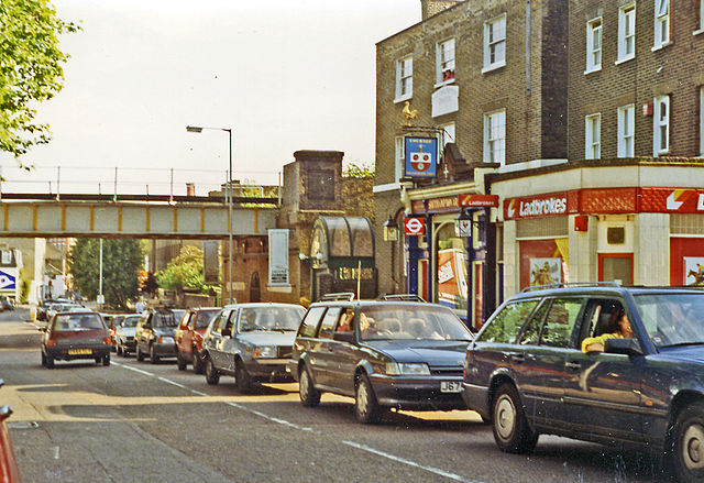
English: Southward on B518 (Highgate Road) at Gordon House Road, near former site of Highgate Road station. The nearer railway bridge carries the ex-Tottenham & Hampstead line, with Gospel Oak station a half mile to the right. Off to the left is Highgate Road Junction, where the loop to Kentish Town turned SW, crossing the second bridge - barely visible, on which Highgate Road (Midland) station was situated (until March 1918), the loop being closed from 5/1/81 and the service from Barking diverted to Gospel Oak. |
| Date | |
| Source | From geograph.org.uk |
| Author | Ben Brooksbank |
| Permission (Reusing this file) |
Creative Commons Attribution Share-alike license 2.0 |
| Attribution (required by the license) | Ben Brooksbank / Southward on B518 (Highgate Road) at Gordon House Road, near former site of Highgate Road station / |
| Camera location | | View this and other nearby images on: OpenStreetMap |
|---|
Licensing
[edit]

|
This image was taken from the Geograph project collection. See this photograph's page on the Geograph website for the photographer's contact details. The copyright on this image is owned by Ben Brooksbank and is licensed for reuse under the Creative Commons Attribution-ShareAlike 2.0 license.
|
This file is licensed under the Creative Commons Attribution-Share Alike 2.0 Generic license.
Attribution: Ben Brooksbank
- You are free:
- to share – to copy, distribute and transmit the work
- to remix – to adapt the work
- Under the following conditions:
- attribution – You must give appropriate credit, provide a link to the license, and indicate if changes were made. You may do so in any reasonable manner, but not in any way that suggests the licensor endorses you or your use.
- share alike – If you remix, transform, or build upon the material, you must distribute your contributions under the same or compatible license as the original.
File history
Click on a date/time to view the file as it appeared at that time.
| Date/Time | Thumbnail | Dimensions | User | Comment | |
|---|---|---|---|---|---|
| current | 09:38, 20 October 2013 | | 2,281 × 1,564 (3.44 MB) | Chevin (talk | contribs) | == {{int:filedesc}} == {{Information |Description={{en|1='''Southward on B518 (Highgate Road) at Gordon House Road, near former site of Highgate Road station.'''<br/> The nearer railway bridge carries the ex-Tottenham & Hampstead line, with Gospel Oak ... |
You cannot overwrite this file.
File usage on Commons
There are no pages that use this file.