File:High Steens Wilderness Study Area (33776952844).jpg

Original file (4,608 × 3,072 pixels, file size: 7.01 MB, MIME type: image/jpeg)
Captions
Captions
Summary
[edit].jpg&action=edit§ion=1)
| Description |
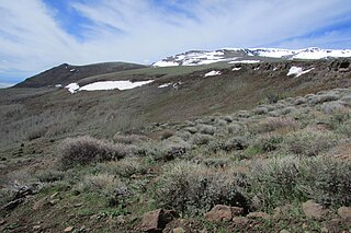
The High Steens Wilderness Study Areas (WSA) is located approximately 60 miles southeast of Burns, Oregon, in Harney County. The WSA is 20 miles east of Frenchglen and Oregon State Highway 205, the nearest highway. The WSA contains 68,485 acres of Bureau of Land Management (BLM) land plus 1,255 acres of split-estate land. In addition, the WSA contains private land totaling 2,165 acres. The WSA is long and somewhat narrow (averaging approximately 20 miles by 9 miles), extending north and south along the east face of Steens Mountain. The boundary of the WSA is formed by a combination of private land and BLM low standard dirt roads. The Steens Mountain Loop Road borders the western border of the WSA, which is a standard gravel road. The WSA is on the east side of the road or the “outside” of the loop. The Steens Mountain Loop Road was constructed, and is maintained, by BLM. It receives substantial use, especially in the upper elevations during the summer months, by sightseers and other recreationists who use it as access to reach the backcountry. The WSA contains a variety of physical features which are the result of volcanism, faulting, glaciation, and erosional processes. From the top of the ridge, the east side of the mountain drops rapidly into the Alvord Desert basin. The elevation difference along this eastern face of the mountain is generally greater than 4,000 feet. At one point, however, the elevation difference is as much as 5,300 feet within 3.5 miles. It is along the eastern boundary that the WSA reaches its lowest elevation of 4,080 feet. The eastern portion of the mountain is deeply carved by numerous drainages and is characterized by steep, rugged, rocky escarpments, and ridgelines. Ten drainages on this eastern slope originate from spring flows and nearly perennial snow fields near the mountain’s summit. From north to south these drainages include Mann, Castle Rock, Little McCoy, Mosquito, Willow, Cottonwood, Big Alvord, Little Alvord, Pike, and Indian Creeks. Glacial action has carved portions of the upper ends of many of these drainages, leaving small U-shaped basins with meadows of lush vegetation at high elevations along the eastern slope. Primitive recreation opportunities include hiking, backpacking, horseback riding, hunting, fishing, sightseeing, and photography. <a href="https://www.blm.gov/programs/national-conservation-lands/oregon-washington" rel="nofollow">www.blm.gov/programs/national-conservation-lands/oregon-w...</a> |
| Date | |
| Source | High Steens Wilderness Study Area |
| Author | Bureau of Land Management Oregon and Washington from Portland, America |
Licensing
[edit].jpg&action=edit§ion=2)
- You are free:
- to share – to copy, distribute and transmit the work
- to remix – to adapt the work
- Under the following conditions:
- attribution – You must give appropriate credit, provide a link to the license, and indicate if changes were made. You may do so in any reasonable manner, but not in any way that suggests the licensor endorses you or your use.
| This image was originally posted to Flickr by BLMOregon at https://flickr.com/photos/50169152@N06/33776952844 (archive). It was reviewed on 13 May 2018 by FlickreviewR 2 and was confirmed to be licensed under the terms of the cc-by-2.0. |
| This image is a work of a Bureau of Land Management* employee, taken or made as part of that person's official duties. As a work of the U.S. federal government, the image is in the public domain in the United States. *or predecessor organization |
USGov files uploaded by OceanAtoll
| This image is a work of a Bureau of Land Management* employee, taken or made as part of that person's official duties. As a work of the U.S. federal government, the image is in the public domain in the United States. *or predecessor organization |
File history
Click on a date/time to view the file as it appeared at that time.
| Date/Time | Thumbnail | Dimensions | User | Comment | |
|---|---|---|---|---|---|
| current | 16:13, 13 May 2018 | | 4,608 × 3,072 (7.01 MB) | OceanAtoll (talk | contribs) | Transferred from Flickr via #flickr2commons |
You cannot overwrite this file.
File usage on Commons
There are no pages that use this file.
.jpg&oldid=897520153)