File:High-speed steam engine - Snibston - geograph.org.uk - 2160613.jpg
Jump to navigation
Jump to search
Size of this preview: 400 × 600 pixels. Other resolutions: 160 × 240 pixels | 427 × 640 pixels.
Original file (427 × 640 pixels, file size: 82 KB, MIME type: image/jpeg)
Captions
Captions
Add a one-line explanation of what this file represents
Summary
[edit]
| Description |
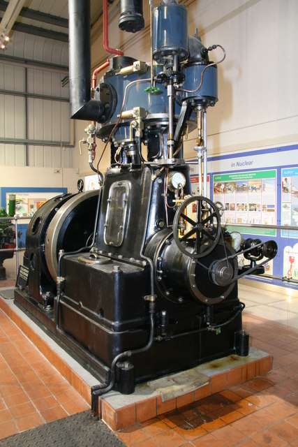
English: High-speed steam engine - Snibston, near to Coalville, Leicestershire, Great Britain.
Belliss & Morcom inverted vertical compound (enclosed) engine, No. 7873 of 1928. This developed 150 brake horsepower at 500 rpm and is direct coupled to an alternator. It was installed at the Princes Drive sewage pumping station at Leamington Spa <a href="https://www.geograph.org.uk/photo/421411">SP3065 : Princes Drive Sewage Pumping Station</a> <a href="https://www.geograph.org.uk/photo/1650193">SP3065 : Princes Drive Sewage Pumping station</a>. The condensing plant was not installed when it was re-erected at Snibston. |
| Date | |
| Source | From geograph.org.uk; transferred by User:Andy Dingley using geograph_org2commons. |
| Author | Chris Allen |
| Permission (Reusing this file) |
Creative Commons Attribution Share-alike license 2.0 |
| Attribution (required by the license) | Chris Allen / High-speed steam engine - Snibston / |
| Camera location | | View this and other nearby images on: OpenStreetMap |
|---|
| Object location | | View this and other nearby images on: OpenStreetMap |
|---|
_region:GB-GBN_&language=en)
Licensing
[edit]

|
This image was taken from the Geograph project collection. See this photograph's page on the Geograph website for the photographer's contact details. The copyright on this image is owned by Chris Allen and is licensed for reuse under the Creative Commons Attribution-ShareAlike 2.0 license.
|
This file is licensed under the Creative Commons Attribution-Share Alike 2.0 Generic license.
Attribution: Chris Allen
- You are free:
- to share – to copy, distribute and transmit the work
- to remix – to adapt the work
- Under the following conditions:
- attribution – You must give appropriate credit, provide a link to the license, and indicate if changes were made. You may do so in any reasonable manner, but not in any way that suggests the licensor endorses you or your use.
- share alike – If you remix, transform, or build upon the material, you must distribute your contributions under the same or compatible license as the original.
File history
Click on a date/time to view the file as it appeared at that time.
| Date/Time | Thumbnail | Dimensions | User | Comment | |
|---|---|---|---|---|---|
| current | 02:23, 5 January 2011 | | 427 × 640 (82 KB) | File Upload Bot (Magnus Manske) (talk | contribs) |
You cannot overwrite this file.
File usage on Commons
There are no pages that use this file.