File:High-Deck-Siedlung 12.jpg
Jump to navigation
Jump to search

Size of this preview: 799 × 599 pixels. Other resolutions: 320 × 240 pixels | 640 × 480 pixels | 1,024 × 768 pixels | 1,280 × 960 pixels | 2,560 × 1,921 pixels | 3,411 × 2,559 pixels.
Original file (3,411 × 2,559 pixels, file size: 2.83 MB, MIME type: image/jpeg)
Captions
Captions
Add a one-line explanation of what this file represents
Summary
[edit]
| Description |
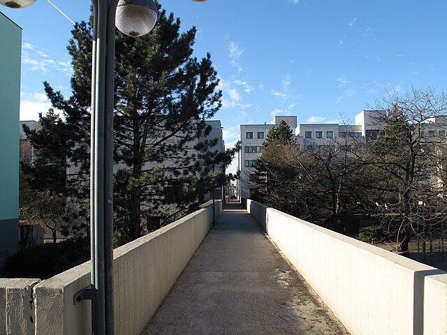
Deutsch: Quersteg zwischen den Decks im Südteil der High-Deck-Siedlung. Die High-Deck-Siedlung ist eine Großsiedlung mit rund 6.000 Bewohnern in Berlin-Neukölln. Die Siedlung entstand in den 1970er/1980er-Jahren im Rahmen des Sozialen Wohnungsbaus. Das innovative städtebauliche Konzept der Architekten Rainer Oefelein und Bernhard Freund wandte sich gegen das in Berlin zu dieser Zeit gängige Hochhaus-Konzept der „Urbanität durch Dichte“ und setzte auf eine baulich-funktionale Trennung von Fußgängern und Autoverkehr. Über den Straßen hochgelagerte, begrünte Wege (die namensgebenden High-Decks) verbinden die überwiegend fünf- bis sechsgeschossigen Gebäude. Galten die Wohnungen nach ihrem Bau als Inbegriff für zeitgemäßes Wohnen am grünen Rand West-Berlins, entwickelte sich die Siedlung nach der Maueröffnung durch Segregation zum Sozialen Brennpunkt und erhielt 1999 ein Quartiersmanagement.
English: Cross way connecting the decks in the southern part of the High-Deck-Siedlung. The High-Deck-Siedlung is a housing estate in Berlin-Neukölln with ca. 6.000 inhabitants. The estate was built in the 1970s/1980s within the subsidized housing by the architects Rainer Oefelein and Bernhard Freund. Their innovative urban development concept counted on a structurally separation of pedestrians and traffic in opposition to Berlin's „urbanity through density“ conception (high-rise-estates) at that time. Above the streets spandrel-braced, green foot pathes (the High-Decks) connect the mainly five to six storied houses. Was the estate after it's construction regarded as the epitome of a tranquil and modern urban living at the green edge of West Berlin, it has evolved after the fall of Berlins Wall into a social hotspot. There was set up a neighbourhood management in 1999. |
| Date | |
| Source | Own work |
| Author | Lienhard Schulz |
Licensing
[edit]
I, the copyright holder of this work, hereby publish it under the following license:
This file is licensed under the Creative Commons Attribution-Share Alike 3.0 Unported license.
- You are free:
- to share – to copy, distribute and transmit the work
- to remix – to adapt the work
- Under the following conditions:
- attribution – You must give appropriate credit, provide a link to the license, and indicate if changes were made. You may do so in any reasonable manner, but not in any way that suggests the licensor endorses you or your use.
- share alike – If you remix, transform, or build upon the material, you must distribute your contributions under the same or compatible license as the original.
File history
Click on a date/time to view the file as it appeared at that time.
| Date/Time | Thumbnail | Dimensions | User | Comment | |
|---|---|---|---|---|---|
| current | 18:34, 10 March 2011 | | 3,411 × 2,559 (2.83 MB) | Lienhard Schulz (talk | contribs) | {{Information| |Description= {{de|Quersteg zwischen den Decks im Südteil der High-Deck-Siedlung. Der Steg im Vordergrund verbindet das Deck mit dem Wohnblock an der Neuköllnischen Allee. Die High-Deck-Siedlung ist eine [[:de:G |
You cannot overwrite this file.
File usage on Commons
There are no pages that use this file.