File:Hidatsa village Sakakawea (32ME11) at Knife River. 1911 map by George F. Will.png
Jump to navigation
Jump to search

Size of this preview: 559 × 599 pixels. Other resolutions: 224 × 240 pixels | 448 × 480 pixels | 717 × 768 pixels | 1,227 × 1,315 pixels.
Original file (1,227 × 1,315 pixels, file size: 1.24 MB, MIME type: image/png)
Captions
Captions
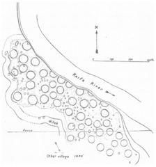
The 1911 map of the Awatixa Hidatsa village Sakakawea (32ME11)
Summary
[edit]_at_Knife_River._1911_map_by_George_F._Will.png&action=edit§ion=1)
| Description |
Dansk: Kortet viser hidatsaernes by Sakakawea (32ME11) ved Knife River i Mercer County, North Dakota, der var beboet fra ca. 1795 til foråret 1834. George F. Will opmålte byen i 1911. Hver cirkel repræsenterer en jordhytte. Dele af byen er styrtet i Knife River. Området er en del af Knife River Indian Villages National Historic Site.
English: The map shows the village of the Awatixa Hidatsa Sakakawea (32ME11) at Knife River, Mercer County, North Dakota. The people lived there from around 1795 to the spring 1834. George F. Will made the map in 1911. Every circle indicates an earthlodge. Part of the village is taken by the river. The area is located in Knife River Indian Villages National Historic Site. |
| Date | |
| Source | Will, G. F.: ”Archaeology of the Missouri Valley." Anthropological Papers of the American Museum of Natural History. 22 (6), 1924. New York. Page 324, fig. 9 |
| Author | George F. Will |
Licensing
[edit]_at_Knife_River._1911_map_by_George_F._Will.png&action=edit§ion=2)
This work is in the public domain in the United States because it was published (or registered with the U.S. Copyright Office) before January 1, 1929.
Public domain works must be out of copyright in both the United States and in the source country of the work in order to be hosted on the Commons. If the work is not a U.S. work, the file must have an additional copyright tag indicating the copyright status in the source country.
Note: This tag should not be used for sound recordings. |

|
This is a file uploaded through the Danish Wikipedia, which has not been reviewed on Commons:
|
File history
Click on a date/time to view the file as it appeared at that time.
| Date/Time | Thumbnail | Dimensions | User | Comment | |
|---|---|---|---|---|---|
| current | 08:33, 20 July 2022 | | 1,227 × 1,315 (1.24 MB) | Indianertosset (talk | contribs) | Uploaded a work by George F. Will from Will, G. F.: ”Archaeology of the Missouri Valley." Anthropological Papers of the American Museum of Natural History. 22 (6), 1924. New York. Page 324, fig. 9 with UploadWizard |
You cannot overwrite this file.
File usage on Commons
There are no pages that use this file.
File usage on other wikis
The following other wikis use this file:
- Usage on da.wikipedia.org
_at_Knife_River._1911_map_by_George_F._Will.png&oldid=675994522)