File:Hibok Hibok Volcano Crater.jpg
![File:Hibok Hibok Volcano Crater.jpg](https://upload.wikimedia.org/wikipedia/commons/thumb/8/8f/Hibok_Hibok_Volcano_Crater.jpg/800px-Hibok_Hibok_Volcano_Crater.jpg?20150117175310)
Original file (1,920 × 1,440 pixels, file size: 947 KB, MIME type: image/jpeg)
Captions
Captions
Summary
[edit]DescriptionHibok Hibok Volcano Crater.jpg |
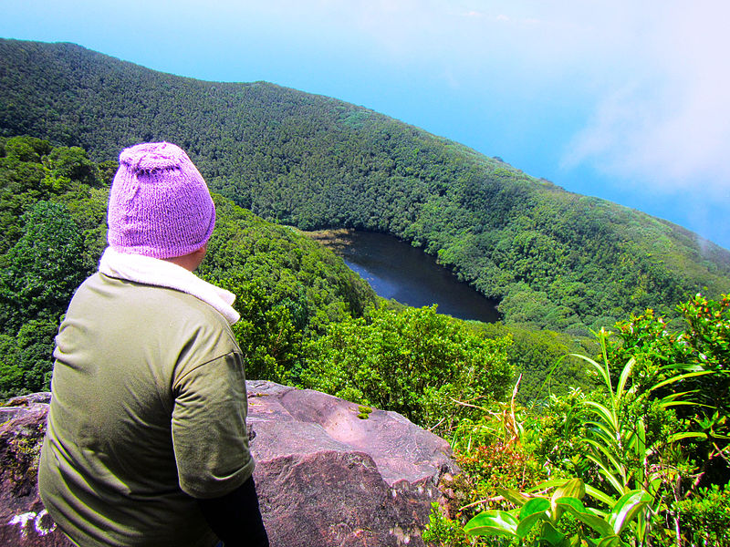
English: Via Yumbing Trail of Hibok-Hibok Volcano, you can pass by its crater and can be used as a camp site for an overnight trek. This shot was taken at 1237MASL after leaving the crater premises and moving onward to the volcano's highest viewpoint at 1332MASL. Shot by Schadow1 Expeditions during its mapping expedition of the volcano last 2013. |
||||||
Date | |||||||
Source | Own work | ||||||
Author | Ervin Malicdem | ||||||
Permission (Reusing this file) |
I, the copyright holder of this work, hereby publish it under the following licenses:
![]() ![]() ![]() This file is licensed under the Creative Commons Attribution-Share Alike 4.0 International license.
You may select the license of your choice.
|
Camera location | 9° 12′ 10.4″ N, 124° 40′ 28.13″ E ![]() ![]() | View this and other nearby images on: OpenStreetMap | ![]() |
---|
Initially published at Schadow1 Expeditions article available at http://www.s1expeditions.com/2013/03/045-hibokhibok-camiguin.html
File history
Click on a date/time to view the file as it appeared at that time.
Date/Time | Thumbnail | Dimensions | User | Comment | |
---|---|---|---|---|---|
current | 17:53, 17 January 2015 | ![]() | 1,920 × 1,440 (947 KB) | Schadow1 (talk | contribs) | User created page with UploadWizard |
You cannot overwrite this file.
File usage on Commons
The following 3 pages use this file:
File usage on other wikis
The following other wikis use this file:
- Usage on en.wikipedia.org
- Usage on fr.wikipedia.org
- Usage on mk.wikipedia.org
Metadata
This file contains additional information such as Exif metadata which may have been added by the digital camera, scanner, or software program used to create or digitize it. If the file has been modified from its original state, some details such as the timestamp may not fully reflect those of the original file. The timestamp is only as accurate as the clock in the camera, and it may be completely wrong.
Camera manufacturer | Canon |
---|---|
Camera model | Canon PowerShot D20 |
Exposure time | 1/640 sec (0.0015625) |
F-number | f/3.9 |
ISO speed rating | 200 |
Date and time of data generation | 12:43, 28 February 2013 |
Lens focal length | 5 mm |
Latitude | 9° 12′ 10.4″ N |
Longitude | 124° 40′ 28.13″ E |
Altitude | 1,237.6 meters above sea level |
Orientation | Normal |
Horizontal resolution | 180 dpi |
Vertical resolution | 180 dpi |
File change date and time | 12:43, 28 February 2013 |
Y and C positioning | Centered |
Exif version | 2.3 |
Date and time of digitizing | 12:43, 28 February 2013 |
Meaning of each component |
|
APEX shutter speed | 9.3128829536528 |
APEX aperture | 3.9269482450922 |
APEX exposure bias | 0 |
Maximum land aperture | 3.9269482450922 APEX (f/3.9) |
Metering mode | Pattern |
Flash | Flash did not fire, auto mode |
Supported Flashpix version | 1 |
Color space | sRGB |
Focal plane X resolution | 16,393.442622951 |
Focal plane Y resolution | 16,393.442622951 |
Focal plane resolution unit | inches |
Sensing method | One-chip color area sensor |
File source | Digital still camera |
Custom image processing | Normal process |
Exposure mode | Auto exposure |
White balance | Auto white balance |
Digital zoom ratio | 1 |
Scene capture type | Standard |
GPS time (atomic clock) | 04:43 |
Receiver status | Measurement in progress |
Geodetic survey data used | WGS-84 |
GPS date | 28 February 2013 |
GPS tag version | 0.0.3.2 |