File:Hermit's Corner - geograph.org.uk - 778008.jpg
Jump to navigation
Jump to search
No higher resolution available.
Hermit's_Corner_-_geograph.org.uk_-_778008.jpg (640 × 427 pixels, file size: 233 KB, MIME type: image/jpeg)
Captions
Captions
Add a one-line explanation of what this file represents
Summary
[edit]
| Description |
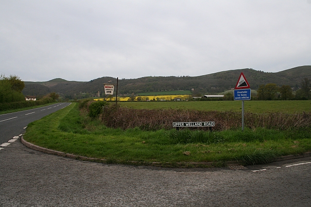
English: Hermit's Corner The junction of Upper Welland Road and the A4104 Welland to Little Malvern Road. The sign shows the steepness of the other end of the Upper Welland Road where it meets the Wells Road running alongside the Malvern Hills. The village store and post office has been saved by the Spar chain and the sign invites passing traffic to take the detour for the shop. The sign used to advertise the Hawthorn Inn which has recently closed. The bright yellow rape occupies North Field in Little Malvern. The Priory can just be seen behind the shop sign. British Camp (our Weathertop) watches over the road. Old local residents named this junction Hermit's Corner because, they claimed, a homeless recluse used to sleep around here. |
| Date | |
| Source | From geograph.org.uk |
| Author | Bob Embleton |
| Attribution (required by the license) | Bob Embleton / Hermit's Corner / |
| Camera location | | View this and other nearby images on: OpenStreetMap |
|---|
_heading:270.00&language=en)
| Object location | | View this and other nearby images on: OpenStreetMap |
|---|
_heading:270.00&language=en)
Licensing
[edit]

|
This image was taken from the Geograph project collection. See this photograph's page on the Geograph website for the photographer's contact details. The copyright on this image is owned by Bob Embleton and is licensed for reuse under the Creative Commons Attribution-ShareAlike 2.0 license.
|
This file is licensed under the Creative Commons Attribution-Share Alike 2.0 Generic license.
Attribution: Bob Embleton
- You are free:
- to share – to copy, distribute and transmit the work
- to remix – to adapt the work
- Under the following conditions:
- attribution – You must give appropriate credit, provide a link to the license, and indicate if changes were made. You may do so in any reasonable manner, but not in any way that suggests the licensor endorses you or your use.
- share alike – If you remix, transform, or build upon the material, you must distribute your contributions under the same or compatible license as the original.
- Remove redundant categories and try to put this image in the most specific category/categories
- Remove this template
- The location categories are based on information from this geonames tool and this OpenStreetMap tool combined with a database. You can also have a look at this tool from mysociety.
- The topic category from Geograph was Road junction (find similar images junction at Geograph)
File history
Click on a date/time to view the file as it appeared at that time.
| Date/Time | Thumbnail | Dimensions | User | Comment | |
|---|---|---|---|---|---|
| current | 22:02, 19 February 2011 | | 640 × 427 (233 KB) | GeographBot (talk | contribs) | == {{int:filedesc}} == {{Information |description={{en|1=Hermit's Corner The junction of Upper Welland Road and the A4104 Welland to Little Malvern Road. The sign shows the steepness of the other end of the Upper Welland Road where it meets the Wells Road |
You cannot overwrite this file.
File usage on Commons
There are no pages that use this file.