File:Hemel Hempstead, Phoenix Gateway sculpture - geograph.org.uk - 1255147.jpg
Hemel_Hempstead,_Phoenix_Gateway_sculpture_-_geograph.org.uk_-_1255147.jpg (640 × 480 pixels, file size: 57 KB, MIME type: image/jpeg)
Captions
Captions
Summary
[edit]| DescriptionHemel Hempstead, Phoenix Gateway sculpture - geograph.org.uk - 1255147.jpg |
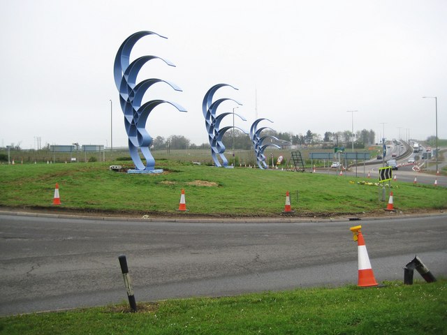
English: Hemel Hempstead: Phoenix Gateway sculpture The sculpture has been designed to reflect the recovery of Hemel Hempstead, and the Maylands business estate in particular, from the Buncefield oil depot explosion in 2005. It was designed by Jose Zavala, and is engineered to withstand tornado force winds and impact by a lorry. This is just as well because it is situated on the roundabout at the entrance to Hemel from the end of the spur road from the M1 Motorway at Junction 8, which is visible in the distance. At this point the motorway turns into the A414 Breakspear Way.
The sculpture's approximate £350,000 cost was funded mainly by the East of England Development Agency (EEDA) with a contribution from the local authority, Dacorum Borough Council. The Ordnance Survey's 1:10,000 scale map shows that the boundary between the Dacorum and St Albans local government areas crosses north to south over the eastern side of the roundabout, and, on that basis, the farthest away of the three fabrications is in St Albans not Dacorum. Obviously a little tidying up and landscaping of the roundabout needs to be undertaken yet. |
| Date | |
| Source | From geograph.org.uk |
| Author | Nigel Cox |
| Other versions | Derivative works of this file: Hemel Hempstead, Phoenix Gateway sculpture.jpg |
| Attribution (required by the license) InfoField | Nigel Cox / Hemel Hempstead: Phoenix Gateway sculpture / |
InfoField | Nigel Cox / Hemel Hempstead: Phoenix Gateway sculpture |
| Camera location | 51° 45′ 22″ N, 0° 25′ 27″ W | View this and other nearby images on: OpenStreetMap |
|---|
| Object location | 51° 45′ 23″ N, 0° 25′ 25″ W | View this and other nearby images on: OpenStreetMap |
|---|
Licensing
[edit]
|
This image was taken from the Geograph project collection. See this photograph's page on the Geograph website for the photographer's contact details. The copyright on this image is owned by Nigel Cox and is licensed for reuse under the Creative Commons Attribution-ShareAlike 2.0 license.
|
- You are free:
- to share – to copy, distribute and transmit the work
- to remix – to adapt the work
- Under the following conditions:
- attribution – You must give appropriate credit, provide a link to the license, and indicate if changes were made. You may do so in any reasonable manner, but not in any way that suggests the licensor endorses you or your use.
- share alike – If you remix, transform, or build upon the material, you must distribute your contributions under the same or compatible license as the original.
|
The photographic reproduction of this work is covered under United Kingdom law (Section 62 of the Copyright, Designs and Patents Act 1988), which states that it is not an infringement to take photographs of buildings, or of sculptures, models for buildings, or works of artistic craftsmanship permanently located in a public place or in premises open to the public. This does not apply to two-dimensional graphic works such as posters or murals. See COM:CRT/United Kingdom#Freedom of panorama for more information.
العربية ∙ Deutsch ∙ English ∙ español ∙ français ∙ 日本語 ∙ 한국어 ∙ македонски ∙ Nederlands ∙ português ∙ português do Brasil ∙ 简体中文 ∙ 繁體中文 ∙ +/− |
|
This work might not be available under a free license in the United States because it is based on an artwork or sculpture that may be protected by copyright under U.S. law. (Commons is hosted in the United States and as such, U.S. law is applicable.)
This is not a valid license tag on Commons; this file must be usable under freedom of panorama in its source country or it will be deleted.
català ∙ Deutsch ∙ English ∙ español ∙ français ∙ italiano ∙ português ∙ português do Brasil ∙ sicilianu ∙ македонски ∙ 한국어 ∙ 日本語 ∙ 简体中文 ∙ 繁體中文 ∙ +/− |
File history
Click on a date/time to view the file as it appeared at that time.
| Date/Time | Thumbnail | Dimensions | User | Comment | |
|---|---|---|---|---|---|
| current | 20:11, 26 February 2011 |  | 640 × 480 (57 KB) | GeographBot (talk | contribs) | == {{int:filedesc}} == {{Information |description={{en|1=Hemel Hempstead: Phoenix Gateway sculpture The sculpture has been designed to reflect the recovery of Hemel Hempstead, and the Maylands business estate in particular, from the Buncefield oil depot e |
You cannot overwrite this file.
File usage on Commons
The following page uses this file:
File usage on other wikis
The following other wikis use this file:
- Usage on en.wikipedia.org
Metadata
This file contains additional information such as Exif metadata which may have been added by the digital camera, scanner, or software program used to create or digitize it. If the file has been modified from its original state, some details such as the timestamp may not fully reflect those of the original file. The timestamp is only as accurate as the clock in the camera, and it may be completely wrong.
| _error | 0 |
|---|
Structured data
Items portrayed in this file
depicts
12 April 2009
51°45'22.3"N, 0°25'27.1"W
51°45'22.64"N, 0°25'25.32"W
- Files with derivative versions
- Information field template with formatting
- Files with coordinates missing SDC location of creation (51° N, 1° W)
- CC-BY-SA-2.0
- Images from Geograph Britain and Ireland
- Images from Geograph Britain and Ireland missing SDC depicts
- Images from Geograph Britain and Ireland missing SDC location of creation
- Images from Geograph Britain and Ireland missing SDC MIME type
- FoP-United Kingdom
- Freedom of panorama works possibly copyrighted in the U.S.
- Photographs by Nigel Cox
- United Kingdom photographs taken on 2009-04-12
