File:Helical antennas were tested with a Microlock receiver in Earthquake Valley. 331-2547d.jpg

Original file (1,500 × 852 pixels, file size: 281 KB, MIME type: image/jpeg)
Captions
Captions
Summary
[edit]
| Description |
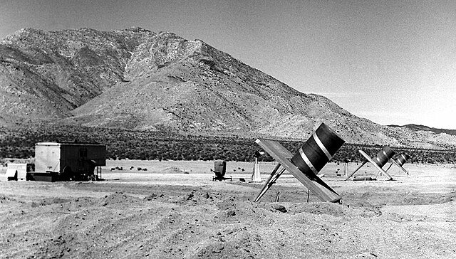
English: Photo showed a prototype antenna tested near JPL in March 1956. Two months later in Earthquake Valley, San Diego County, similar helical antennas were tested in conjunction with a Microlock receiver. Two objectives of the tests were to gain experience with the Microlock ground station equipment and determine the accuracy of the interferometer antenna system.
Three of the helical antennas were spaced just over 100 feet apart. Two phototheodolites behind the antennas were used to measure the system's angular accuracy. The van at the far left contained the receiver equipment and other instruments. A helicopter towing a transmitting beacon was again used to simulate the signal of a satellite in orbit. It was determined that the system could track a beacon of 1 milliwatt at a distance of about 6,000 miles. The low ambient noise level in Earthquake Valley helped to increase the receiver's performance, compared to the tests done near JPL. The next step in the development of satellite communications can be seen in photo 293-3885Bc. It shows the mobile tracking system used for the Explorer 1, and Pioneer 3 and 4 spacecraft. |
| Date | |
| Source | https://pub-lib.jpl.nasa.gov/docushare/dsweb/View/Collection-115 |
| Author | NASA |
Licensing
[edit]
| This file is in the public domain in the United States because it was solely created by NASA. NASA copyright policy states that "NASA material is not protected by copyright unless noted". (See Template:PD-USGov, NASA copyright policy page or JPL Image Use Policy.) | ||
 |
Warnings:
|
File history
Click on a date/time to view the file as it appeared at that time.
| Date/Time | Thumbnail | Dimensions | User | Comment | |
|---|---|---|---|---|---|
| current | 17:46, 13 January 2019 | | 1,500 × 852 (281 KB) | Pline (talk | contribs) | User created page with UploadWizard |
You cannot overwrite this file.
File usage on Commons
The following page uses this file: