File:Heinrich Kiepert, Übersichtsplan von Jerusalem 02 (FL198245554 1141892).jpg
Jump to navigation
Jump to search
Size of this preview: 391 × 600 pixels. Other resolutions: 156 × 240 pixels | 313 × 480 pixels | 500 × 768 pixels | 667 × 1,024 pixels | 2,453 × 3,764 pixels.
Original file (2,453 × 3,764 pixels, file size: 8.09 MB, MIME type: image/jpeg)
Captions
Captions
Add a one-line explanation of what this file represents
Summary
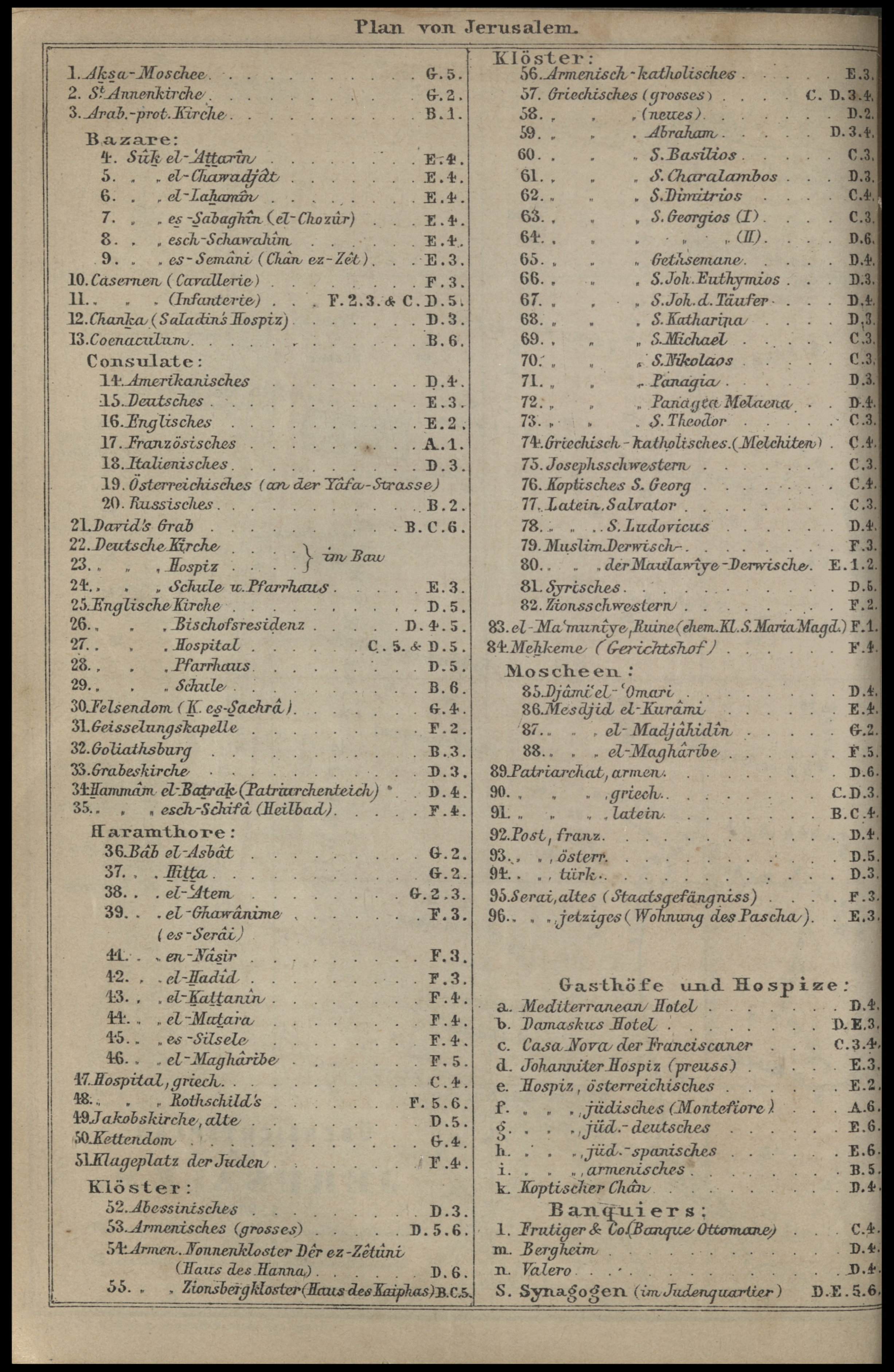
[edit]| Heinrich Kiepert: Übersichtsplan von Jerusalem
( |
||||||||||||||||||||||||
|---|---|---|---|---|---|---|---|---|---|---|---|---|---|---|---|---|---|---|---|---|---|---|---|---|
| Artist |
|
|||||||||||||||||||||||
| Title |
Übersichtsplan von Jerusalem |
|||||||||||||||||||||||
| Publisher |
Karl Baedeker |
|||||||||||||||||||||||
| Description |
Übersichtsplan von Jerusalem. Gez. v. H. Kiepert. |
|||||||||||||||||||||||
| Language | German | |||||||||||||||||||||||
| Publication date | 1880 | |||||||||||||||||||||||
| Medium | 1 sheet : color ; | |||||||||||||||||||||||
| Dimensions | 15 × 20 cm (5.9 × 7.8 in) | |||||||||||||||||||||||
| Collection |
|
|||||||||||||||||||||||
| Current location |
|
|||||||||||||||||||||||
| Place of publication | Leipzig | |||||||||||||||||||||||
| search Merhav catalog | Leipzig | |||||||||||||||||||||||
| Notes | In: Palästina und Syrien: Handbuch für reisende, herausgegeben von K. Baedeker. 1880 [34 B 1220], between pp. 20-21. Map and index page.; כולל סימון קונסוליות, וכן בנקים: פרוטיגר, ולרו VALERO, Bergheim, FRUTIGER. | |||||||||||||||||||||||
| scale | 1:8,300 cm | |||||||||||||||||||||||
| IE PID | IE198245551 | |||||||||||||||||||||||
| Rosetta filename | FL198245554 | |||||||||||||||||||||||
| NNL item ID (P3959) | 997011418926205171 | |||||||||||||||||||||||
| search Merhav catalog | German, Heinrich Kiepert | |||||||||||||||||||||||
| search Merhav catalog | Karl Baedeker | |||||||||||||||||||||||
| Source/Photographer |
|
|||||||||||||||||||||||
| Other versions | ||||||||||||||||||||||||
| Jpg / Tif version |
|
|||||||||||||||||||||||
Loescher_%26_btv1b8453164n_(cropped).jpg)

.jpg)

.jpg&action=edit§ion=1)
Licensing
[edit].jpg&action=edit§ion=2)
The copyright situation of this work is theoretically uncertain, because in the country of origin copyright lasts 70 years after the death of the author, and the date of the author's death is unknown. However, the date of creation of the work was over 120 years ago, and it is thus a reasonable assumption that the copyright has expired (see here for the community discussion). Do not use this template if the date of death of the author is known.
| |
| This file has been identified as being free of known restrictions under copyright law, including all related and neighboring rights. | |
File history
Click on a date/time to view the file as it appeared at that time.
| Date/Time | Thumbnail | Dimensions | User | Comment | |
|---|---|---|---|---|---|
| current | 13:21, 16 August 2023 | | 2,453 × 3,764 (8.09 MB) | Geagea (talk | contribs) | pattypan 22.03 |
You cannot overwrite this file.
File usage on Commons
The following page uses this file:
.jpg&oldid=808935665)