File:Heinrich Bünting, Beschreibung des heiligen Landes Canaan (FL6882245 2368405).jpg
Jump to navigation
Jump to search

Size of this preview: 348 × 599 pixels. Other resolutions: 139 × 240 pixels | 279 × 480 pixels | 446 × 768 pixels | 594 × 1,024 pixels | 1,900 × 3,272 pixels.
Original file (1,900 × 3,272 pixels, file size: 3.41 MB, MIME type: image/jpeg)
Captions
Captions
Add a one-line explanation of what this file represents
Summary
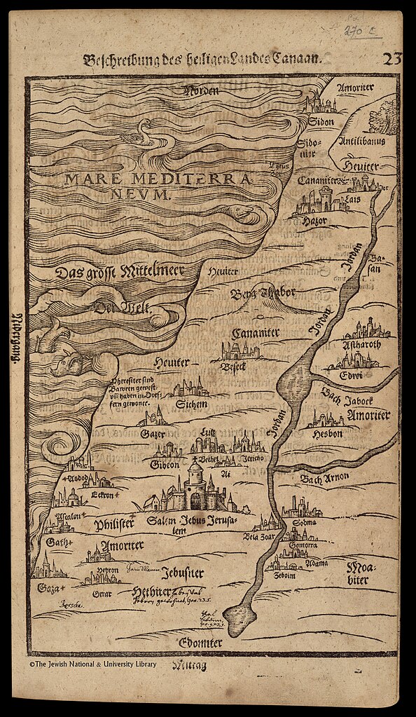
[edit]| Heinrich Bünting: Beschreibung des heiligen Landes Canaan
( |
||||||||||||||||||||||||||
|---|---|---|---|---|---|---|---|---|---|---|---|---|---|---|---|---|---|---|---|---|---|---|---|---|---|---|
| Artist |
| |||||||||||||||||||||||||
| Contributors | Duncker, Andreas | |||||||||||||||||||||||||
| Title |
Beschreibung des heiligen Landes Canaan |
|||||||||||||||||||||||||
| Publisher |
Andreas Duncker |
|||||||||||||||||||||||||
| Description |
Beschreibung des heiligen Landes Canaan. |
|||||||||||||||||||||||||
| Language | German | |||||||||||||||||||||||||
| Publication date | 1600 | |||||||||||||||||||||||||
| Dimensions | 265 × 172 mm (10.43 × 6.77 in) | |||||||||||||||||||||||||
| Collection |
|
|||||||||||||||||||||||||
| Current location |
|
|||||||||||||||||||||||||
| Place of publication | Magdeburg | |||||||||||||||||||||||||
| search Merhav catalog | Magdeburg | |||||||||||||||||||||||||
| Notes | Woodcut; German text on verso; From: BÜnting, Heinrich, Itinerarium Sacre Scipturae. Magdeburg, Andreas Duncker, 1600. Pt.I, p.23. First edition 1581. Contains 12 woodcuts, of which 10 are maps | |||||||||||||||||||||||||
| IE PID | IE6882243 | |||||||||||||||||||||||||
| Rosetta filename | FL6882245 | |||||||||||||||||||||||||
| NNL item ID (P3959) | 990023684050205171 | |||||||||||||||||||||||||
| search Merhav catalog | German, Heinrich Bünting | |||||||||||||||||||||||||
| search Merhav catalog | Andreas Duncker | |||||||||||||||||||||||||
| Source/Photographer |
|
|||||||||||||||||||||||||
| Other versions | ||||||||||||||||||||||||||
| Jpg / Tif version |
|
|||||||||||||||||||||||||

.jpg)

.jpg&action=edit§ion=1)
Licensing
[edit].jpg&action=edit§ion=2)
The copyright situation of this work is theoretically uncertain, because in the country of origin copyright lasts 70 years after the death of the author, and the date of the author's death is unknown. However, the date of creation of the work was over 120 years ago, and it is thus a reasonable assumption that the copyright has expired (see here for the community discussion). Do not use this template if the date of death of the author is known.
| |
| This file has been identified as being free of known restrictions under copyright law, including all related and neighboring rights. | |
File history
Click on a date/time to view the file as it appeared at that time.
| Date/Time | Thumbnail | Dimensions | User | Comment | |
|---|---|---|---|---|---|
| current | 06:57, 28 July 2023 | | 1,900 × 3,272 (3.41 MB) | Geagea (talk | contribs) | pattypan 22.03 |
You cannot overwrite this file.
File usage on Commons
The following page uses this file:
.jpg&oldid=788216309)