File:Heinävesi-map canals 3.png
Jump to navigation
Jump to search

Size of this preview: 591 × 600 pixels. Other resolutions: 237 × 240 pixels | 473 × 480 pixels | 693 × 703 pixels.
Original file (693 × 703 pixels, file size: 162 KB, MIME type: image/png)
Captions
Captions
Add a one-line explanation of what this file represents
Summary
[edit]
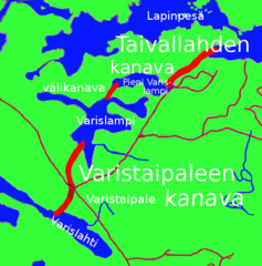
The map made by Pertsaboy.
Heinävesi, Finland: Varistaipale and Taivallahti canals.
Licensing
[edit]

|
Permission is granted to copy, distribute and/or modify this document under the terms of the GNU Free Documentation License, Version 1.2 or any later version published by the Free Software Foundation; with no Invariant Sections, no Front-Cover Texts, and no Back-Cover Texts. A copy of the license is included in the section entitled GNU Free Documentation License. |
| This file is licensed under the Creative Commons Attribution-Share Alike 3.0 Unported license. | ||
| ||
| This licensing tag was added to this file as part of the GFDL licensing update. |
File history
Click on a date/time to view the file as it appeared at that time.
| Date/Time | Thumbnail | Dimensions | User | Comment | |
|---|---|---|---|---|---|
| current | 16:31, 22 March 2006 | | 693 × 703 (162 KB) | Pertsaboy~commonswiki (talk | contribs) | The map made by Pertsaboy. Heinävesi, Finland: Varistaipale and Taivallahti canals. Category:Heinävesi |
You cannot overwrite this file.
File usage on Commons
The following page uses this file:
File usage on other wikis
The following other wikis use this file:
- Usage on fi.wikipedia.org
- Usage on fr.wikipedia.org