File:Hedon Haven - geograph.org.uk - 316934.jpg
Jump to navigation
Jump to search
Size of this preview: 435 × 600 pixels. Other resolutions: 174 × 240 pixels | 464 × 640 pixels.
Original file (464 × 640 pixels, file size: 136 KB, MIME type: image/jpeg)
Captions
Captions
Add a one-line explanation of what this file represents
Summary
[edit]
| Description |
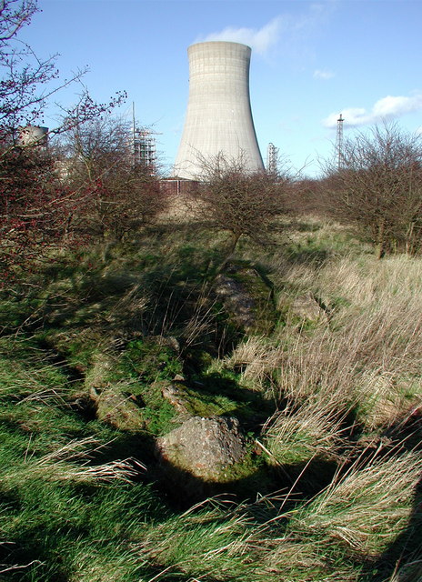
English: Hedon Haven, near Salt End, East Riding of Yorkshire, England. Western end of the old Hedon Haven harbour complex between Pollard Clough and Paull Road. Hedon Haven was a thriving port long before Kingston upon Hull was established as a city but the only immediately apparent remains of the medieval port are earthworks and reedbeds between Salt End and Hedon. Much of the site was probably filled in with tons of rubble from some of the many Hull buildings destroyed by bombing in the Second World War. |
| Date | |
| Source | From geograph.org.uk |
| Author | Paul Glazzard |
| Permission (Reusing this file) |
Creative Commons Attribution Share-alike license 2.0 |
| Attribution (required by the license) | Paul Glazzard / Hedon Haven / |
| Camera location | | View this and other nearby images on: OpenStreetMap |
|---|
_heading:337.00&language=en)
| Object location | | View this and other nearby images on: OpenStreetMap |
|---|
_heading:337.00&language=en)
Licensing
[edit]

|
This image was taken from the Geograph project collection. See this photograph's page on the Geograph website for the photographer's contact details. The copyright on this image is owned by Paul Glazzard and is licensed for reuse under the Creative Commons Attribution-ShareAlike 2.0 license.
|
This file is licensed under the Creative Commons Attribution-Share Alike 2.0 Generic license.
Attribution: Paul Glazzard
- You are free:
- to share – to copy, distribute and transmit the work
- to remix – to adapt the work
- Under the following conditions:
- attribution – You must give appropriate credit, provide a link to the license, and indicate if changes were made. You may do so in any reasonable manner, but not in any way that suggests the licensor endorses you or your use.
- share alike – If you remix, transform, or build upon the material, you must distribute your contributions under the same or compatible license as the original.
File history
Click on a date/time to view the file as it appeared at that time.
| Date/Time | Thumbnail | Dimensions | User | Comment | |
|---|---|---|---|---|---|
| current | 15:05, 30 December 2010 | | 464 × 640 (136 KB) | GeographBot (talk | contribs) | == {{int:filedesc}} == {{Information |description={{en|1=Hedon Haven Western end of the old Hedon Haven harbour complex between Pollard Clough and Paull Road. Hedon Haven was a thriving port long before Kingston upon Hull was established as a city but the |
You cannot overwrite this file.
File usage on Commons
There are no pages that use this file.