File:Heath to Stanley road - geograph.org.uk - 604177.jpg
Heath_to_Stanley_road_-_geograph.org.uk_-_604177.jpg (640 × 360 pixels, file size: 95 KB, MIME type: image/jpeg)
Captions
Captions
Summary
[edit]
| Description |
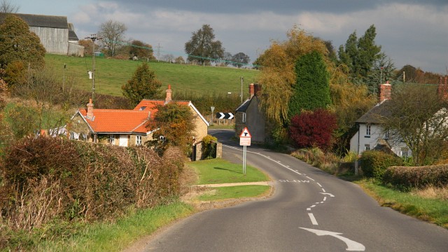
English: Heath to Stanley road. This northerly facing photograph shows the Heath¹ (ahead) to Stanley¹ (behind the viewpoint) road at Stainsbybrook, Stainsby¹.
Ahead, in the middle distance, the three buildings are private dwellings. The red roofed building is Cobblers Cottage¹. The white faced building is Brookside Cottage¹. The cottage in shadow at the corner is Stainsby Brook Cottage¹. The barn in the top left is part of Stainsby Farm¹. Off the right of the picture is the M1 motorway, the construction of which caused this road to be realigned in places. Behind the viewpoint of this photograph a 604184 from Hardstoft¹ joins the road. At Stainsby Brook Cottage there is a road junction, where an unnamed¹ lane leads into 600817¹ and it's junction with 598842¹. For another view of this road (from round the bend at Stainsby Brook Cottage) and looking back toward the junction, click here 597727. For another view² of the road junction taken by Alan Heardman, click here 521615. For a more northerly (ahead, toward Heath) photograph of the road, click here 597658. For a more southerly (behind the viewpoint, toward Stanley) photograph of the road, click here 603599. ¹ Road/Farm/Place/Building name information from OS Maps at:- Elgin, http://www.elgin.gov.uk/ or the Mapping Portal of the Derbyshire Partnership, http://derbyshiremaps.derbyshire.gov.uk/ ² On the left of Alan's photograph is Stainsby Brook Cottage and on the right is Cobblers Cottage. |
| Date | |
| Source | From geograph.org.uk |
| Author | Alan Walker |
| Attribution (required by the license) | Alan Walker / Heath to Stanley road / |
| Camera location | | View this and other nearby images on: OpenStreetMap |
|---|
_heading:0.00&language=en)
| Object location | | View this and other nearby images on: OpenStreetMap |
|---|
_heading:0.00&language=en)
Licensing
[edit]

|
This image was taken from the Geograph project collection. See this photograph's page on the Geograph website for the photographer's contact details. The copyright on this image is owned by Alan Walker and is licensed for reuse under the Creative Commons Attribution-ShareAlike 2.0 license.
|
- You are free:
- to share – to copy, distribute and transmit the work
- to remix – to adapt the work
- Under the following conditions:
- attribution – You must give appropriate credit, provide a link to the license, and indicate if changes were made. You may do so in any reasonable manner, but not in any way that suggests the licensor endorses you or your use.
- share alike – If you remix, transform, or build upon the material, you must distribute your contributions under the same or compatible license as the original.
- Remove redundant categories and try to put this image in the most specific category/categories
- Remove this template
- The location categories are based on information from this geonames tool and this OpenStreetMap tool combined with a database. You can also have a look at this tool from mysociety.
- The topic category from Geograph was Cottages (find similar images at Geograph)
File history
Click on a date/time to view the file as it appeared at that time.
| Date/Time | Thumbnail | Dimensions | User | Comment | |
|---|---|---|---|---|---|
| current | 23:21, 6 February 2011 | | 640 × 360 (95 KB) | GeographBot (talk | contribs) | == {{int:filedesc}} == {{Information |description={{en|1=Heath to Stanley road This northerly facing photograph shows the Heath¹ (ahead) to Stanley¹ (behind the viewpoint) road at Stainsbybrook, Stainsby¹. Ahead, in the middle distance, the three bu |
You cannot overwrite this file.
File usage on Commons
There are no pages that use this file.