File:Hd. Qrs. D. and (A. Tenn.) Aug. 30, 1864, 8 a.m. - (Pencil sketch showing the location of the Headquarters, Department of the Tennessee, on Flint River near Jonesboro, Georgia). LOC 2006459222.jpg
Jump to navigation
Jump to search

Size of this preview: 457 × 599 pixels. Other resolutions: 183 × 240 pixels | 366 × 480 pixels | 586 × 768 pixels | 782 × 1,024 pixels | 1,563 × 2,048 pixels | 2,680 × 3,511 pixels.
Original file (2,680 × 3,511 pixels, file size: 876 KB, MIME type: image/jpeg)
Captions
Captions
Add a one-line explanation of what this file represents
Summary
[edit]| Description |
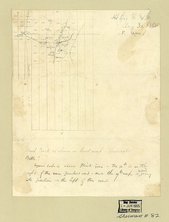
English: Remainder of title from Stephenson's Civil War maps, 1989. Pencil drawn on 3/8 in. numbered grid. LC Civil War maps (2nd ed.), S82, 180 Available also through the Library of Congress Web site as a raster image. In manuscript at bottom: Logan's Corps is across the Flint River - the 16th is on the right of the main Jonesboro road - and the 17th Corps is now going into position on the left of this road. In a different hand at bottom: Mud Creek as shown on land map is incorrect. In manuscript on verso: Jonesboro 1864. Imperfect: Fold-lined. Mounted on paper. Minor loss to sheet/title in upper right corner. |
||
| Title | Hd. Qrs. D. and [A. Tenn.] Aug. 30, 1864, 8 a.m. : [Pencil sketch showing the location of the Headquarters, Department of the Tennessee, on Flint River near Jonesboro, Georgia]. | ||
| Shelf ID | G3924.J7S5 1864 .H4 | ||
| Date | |||
| Source | https://www.loc.gov/item/2006459222/ | ||
| Author | Unknown author | ||
| Permission (Reusing this file) |
|
||
| Other versions |
|
||
| Location | United States · Jonesboro Region · Flint River · Georgia | ||
| Part of | Military Battles And Campaigns · American Memory · Civil War Maps · Catalog · Geography And Map Division | ||
| Subject | Maps, Manuscript · Georgia · Civil War · United States · Flint River (Ga.) · Flint River · Jonesboro Region (Ga.) · Jonesboro Region · History |

_Aug._30,_1864,_8_a.m._-_(Pencil_sketch_showing_the_location_of_the_Headquarters,_Department_of_the_Tennessee,_on_Flint_River_near_Jonesboro,_Georgia)._LOC_2006459222.jpg&action=edit§ion=1)
Licensing
[edit]_Aug._30,_1864,_8_a.m._-_(Pencil_sketch_showing_the_location_of_the_Headquarters,_Department_of_the_Tennessee,_on_Flint_River_near_Jonesboro,_Georgia)._LOC_2006459222.jpg&action=edit§ion=2)
|
This is a faithful photographic reproduction of a two-dimensional, public domain work of art. The work of art itself is in the public domain for the following reason:
The official position taken by the Wikimedia Foundation is that "faithful reproductions of two-dimensional public domain works of art are public domain".
This photographic reproduction is therefore also considered to be in the public domain in the United States. In other jurisdictions, re-use of this content may be restricted; see Reuse of PD-Art photographs for details. | ||||
File history
Click on a date/time to view the file as it appeared at that time.
| Date/Time | Thumbnail | Dimensions | User | Comment | |
|---|---|---|---|---|---|
| current | 18:51, 10 June 2018 | | 2,680 × 3,511 (876 KB) | Fæ (talk | contribs) | LOC Maps https://www.loc.gov/item/2006459222/ #26181 |
You cannot overwrite this file.
File usage on Commons
The following page uses this file:
_Aug._30,_1864,_8_a.m._-_(Pencil_sketch_showing_the_location_of_the_Headquarters,_Department_of_the_Tennessee,_on_Flint_River_near_Jonesboro,_Georgia)._LOC_2006459222.jpg&oldid=745703460)