File:Hauptmarkt Trier.jpg
Jump to navigation
Jump to search

Size of this preview: 799 × 313 pixels. Other resolutions: 320 × 125 pixels | 640 × 251 pixels | 1,024 × 401 pixels | 1,280 × 501 pixels | 2,560 × 1,003 pixels | 9,825 × 3,849 pixels.
Original file (9,825 × 3,849 pixels, file size: 10.64 MB, MIME type: image/jpeg)
Captions
Captions
Add a one-line explanation of what this file represents
Summary
[edit]
| Description |
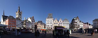
Deutsch: Denkmalzone Marktbezirk: umfasst den Bereich der mittelalterlichen Siedlung am Hauptmarkt: Umbauung des Hauptmarktes und der einmündenden Straßen und des Stockplatzes einschließlich der Markt- und Pfarrkirche St. Gangolph; dreieckiger Grundriss, im 10. Jahrhundert durch Erzbischof Heinrich I. angelegt, planmäßige Baufluchtänderungen vom späten 18. bis zum frühen 20 Jahrhundert, heutige Bebauung romanisch bis 20. Jahrhundert |
| Date | Taken on 15 August 2009 |
| Source | Own work |
| Author | Berthold Werner |
| Permission (Reusing this file) |
GFDL |
| Other versions | http://www.bildindex.de/document/obj20564035?part=0&medium=fmc913134 |
| Camera location | | View this and other nearby images on: OpenStreetMap |
|---|
Licensing
[edit]
I, the copyright holder of this work, hereby publish it under the following licenses:

|
Permission is granted to copy, distribute and/or modify this document under the terms of the GNU Free Documentation License, Version 1.2 or any later version published by the Free Software Foundation; with no Invariant Sections, no Front-Cover Texts, and no Back-Cover Texts. A copy of the license is included in the section entitled GNU Free Documentation License. |
| This file is licensed under the Creative Commons Attribution-Share Alike 3.0 Unported license. | ||
| ||
| This licensing tag was added to this file as part of the GFDL licensing update. |
You may select the license of your choice.
| Annotations | This image is annotated: View the annotations at Commons |
File history
Click on a date/time to view the file as it appeared at that time.
| Date/Time | Thumbnail | Dimensions | User | Comment | |
|---|---|---|---|---|---|
| current | 15:45, 16 August 2009 | 9,825 × 3,849 (10.64 MB) | Berthold Werner (talk | contribs) | Neu fotografiert | |
| 11:10, 7 September 2006 | 3,510 × 1,107 (847 KB) | Berthold Werner (talk | contribs) | {{Information |Description=Hauptmarkt in Trier |Source=own work |Date=2006-09-06 |Author=Berthold Werner |Permission=GFDL |other_versions= }} |
You cannot overwrite this file.
File usage on Commons
The following 5 pages use this file:
File usage on other wikis
The following other wikis use this file:
- Usage on am.wikipedia.org
- Usage on de.wikipedia.org
- Usage on de.wikivoyage.org
- Usage on en.wikipedia.org
- Usage on fa.wikipedia.org
- Usage on gl.wikipedia.org
- Usage on hr.wikipedia.org
- Usage on hu.wikipedia.org
- Usage on id.wikipedia.org
- Usage on ka.wikipedia.org
- Usage on pnb.wikipedia.org
- Usage on pt.wikipedia.org
- Usage on sco.wikipedia.org
- Usage on sh.wikipedia.org
- Usage on sr.wikipedia.org
- Usage on uk.wikipedia.org
- Usage on www.wikidata.org
- Usage on zh.wikipedia.org