File:Harta 3D pentru Piatra Neamt, Romania.jpg
Jump to navigation
Jump to search

Size of this preview: 800 × 600 pixels. Other resolutions: 320 × 240 pixels | 640 × 480 pixels | 1,024 × 768 pixels.
Original file (1,024 × 768 pixels, file size: 503 KB, MIME type: image/jpeg)
Captions
Captions
Add a one-line explanation of what this file represents
Summary
[edit]
| Description |
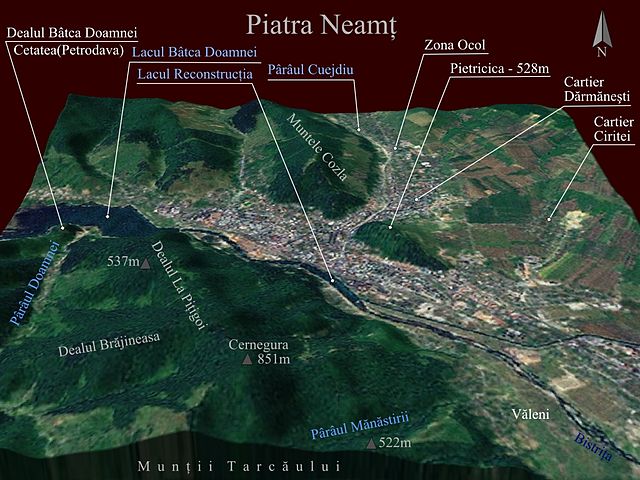
Română: Harta 3D pentru Piatra Neamt, Romania. |
| Date | |
| Source |
|
| Author | Asybaris01 |
| Other versions |
 |
Licensing
[edit]
| This image is in the public domain because it is a screenshot from NASA’s globe software World Wind using a public domain layer, such as Blue Marble, MODIS, Landsat, SRTM, USGS or GLOBE.
|
 |
File history
Click on a date/time to view the file as it appeared at that time.
| Date/Time | Thumbnail | Dimensions | User | Comment | |
|---|---|---|---|---|---|
| current | 17:52, 20 October 2011 | | 1,024 × 768 (503 KB) | Asybaris01 (talk | contribs) | {{Information |Description ={{ro|1=Harta 3D pentru Piatra Neamt, Romania.}} |Source =Topographic data SRTM from NASA and World Imagery - NASA World Wind & 3Dem & Inkscape |Author =Asybaris01 |Date =oct 2011 |
You cannot overwrite this file.
File usage on Commons
The following page uses this file:
File usage on other wikis
The following other wikis use this file:
- Usage on de.wikipedia.org
- Usage on ro.wikipedia.org
- Usage on zh.wikipedia.org