File:Harta 3D pentru Bazinul Raului Megiesul si Pleasa, afluenti ai Oltului.jpg
Jump to navigation
Jump to search

Size of this preview: 787 × 600 pixels. Other resolutions: 315 × 240 pixels | 630 × 480 pixels | 1,008 × 768 pixels | 1,280 × 976 pixels | 1,574 × 1,200 pixels.
Original file (1,574 × 1,200 pixels, file size: 1.13 MB, MIME type: image/jpeg)
Captions
Captions
Add a one-line explanation of what this file represents
Summary
[edit]| Description |
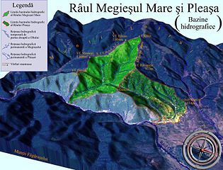
Română: Harta 3D pentru Bazinul Râului Megieșul(verde deschis) și Pleașa(verde închis), afluenți ai Oltului. Selectați alte bazine hidrografice adiacente ale Defileului Oltului, menționate pe hartă în mod senzitiv cu chenare de note informative. |
| Date | |
| Source |
|
| Author | Asybaris01 |
| Other versions |
|

Clickable map of the (ro:Defileul Oltului)/(en:Defile Olt) drainage basin
[edit]
Licensing
[edit]| This image is in the public domain because it is a screenshot from NASA’s globe software World Wind using a public domain layer, such as Blue Marble, MODIS, Landsat, SRTM, USGS or GLOBE.
|
 |
| Annotations | This image is annotated: View the annotations at Commons |


File history
Click on a date/time to view the file as it appeared at that time.
| Date/Time | Thumbnail | Dimensions | User | Comment | |
|---|---|---|---|---|---|
| current | 19:12, 27 October 2011 | | 1,574 × 1,200 (1.13 MB) | Asybaris01 (talk | contribs) | {{Information |Description ={{ro|1=Harta 3D pentru Bazinul Raului Megiesul si Pleasa, afluenti ai Oltului.}} |Source =Topographic data SRTM from NASA and World Imagery - NASA World Wind & 3Dem & Inkscape |Author =[[User:Asybaris01|Asyba |
You cannot overwrite this file.
File usage on Commons
The following 5 pages use this file:
- File:Bazinul hidrografic al Lungsoarei, Talmacel.jpg
- File:Harta 3D a Bazinului Raului Stramba si Valea Marului, afluenti ai Oltului.jpg
- File:Harta 3D pentru bazinele Vaii Boului si a Fratelui, afluenti ai Oltului.jpg
- File:Harta bazinului hidrografic al raului Lotrioara, afluent al Oltului.jpg
- File:Modelare 3D pentru Bazinul Raului Pleasa si Megies, afluenti ai Oltului.gif
File usage on other wikis
The following other wikis use this file:
- Usage on ro.wikipedia.org