File:Harrogate, Windsor House geograph-6945734-by-Mel-Towler.jpg
Jump to navigation
Jump to search

Size of this preview: 690 × 600 pixels. Other resolutions: 276 × 240 pixels | 552 × 480 pixels | 884 × 768 pixels | 1,024 × 890 pixels.
Original file (1,024 × 890 pixels, file size: 352 KB, MIME type: image/jpeg)
Captions
Captions
Add a one-line explanation of what this file represents
Summary
[edit]
| Description |
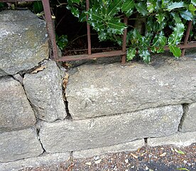
English: Harrogate, Windsor House. This stone boundary wall to Windsor House is on the north side of Cornwall Road. The railings are the extreme left of the road frontage of the property. There is a rivet and benchmark cut into the top stone of the wall. |
| Date | |
| Source | From geograph.org.uk |
| Author | Mel Towler |
| Permission (Reusing this file) |
Creative Commons Attribution Share-alike license 2.0 |
| Attribution (required by the license) | Mel Towler / Harrogate, Windsor House / |
| Camera location | | View this and other nearby images on: OpenStreetMap |
|---|
_heading:337.00&language=en)
| Object location | | View this and other nearby images on: OpenStreetMap |
|---|
_heading:337.00&language=en)
Licensing
[edit]

|
This image was taken from the Geograph project collection. See this photograph's page on the Geograph website for the photographer's contact details. The copyright on this image is owned by Mel Towler and is licensed for reuse under the Creative Commons Attribution-ShareAlike 2.0 license.
|
This file is licensed under the Creative Commons Attribution-Share Alike 2.0 Generic license.
Attribution: Mel Towler
- You are free:
- to share – to copy, distribute and transmit the work
- to remix – to adapt the work
- Under the following conditions:
- attribution – You must give appropriate credit, provide a link to the license, and indicate if changes were made. You may do so in any reasonable manner, but not in any way that suggests the licensor endorses you or your use.
- share alike – If you remix, transform, or build upon the material, you must distribute your contributions under the same or compatible license as the original.
File history
Click on a date/time to view the file as it appeared at that time.
| Date/Time | Thumbnail | Dimensions | User | Comment | |
|---|---|---|---|---|---|
| current | 18:14, 10 March 2023 | | 1,024 × 890 (352 KB) | Geograph Update Bot (talk | contribs) | Higher-resolution version from Geograph |
| 12:36, 21 February 2023 |  | 640 × 556 (138 KB) | Storye book (talk | contribs) | == {{int:filedesc}} == {{Information |Description={{en|1=Harrogate, Windsor House. This stone boundary wall to Windsor House is on the north side of Cornwall Road. The railings are the extreme left of the road frontage of the property. There is a rivet and benchmark cut into the top stone of the wall.}} |Source=From [https://www.geograph.org.uk/photo/6945734 geograph.org.uk] |Date=2021-08-15 |Author=[https://www.geograph.org.uk/profile/135261 Mel Towler] |Permission=Creative Commons Attributi... |
You cannot overwrite this file.
File usage on Commons
There are no pages that use this file.