File:Harbour approach, Portreath - geograph.org.uk - 928785.jpg
Jump to navigation
Jump to search
Size of this preview: 428 × 599 pixels. Other resolutions: 171 × 240 pixels | 457 × 640 pixels.
Original file (457 × 640 pixels, file size: 128 KB, MIME type: image/jpeg)
Captions
Captions
Add a one-line explanation of what this file represents
Summary
[edit]
| Description |
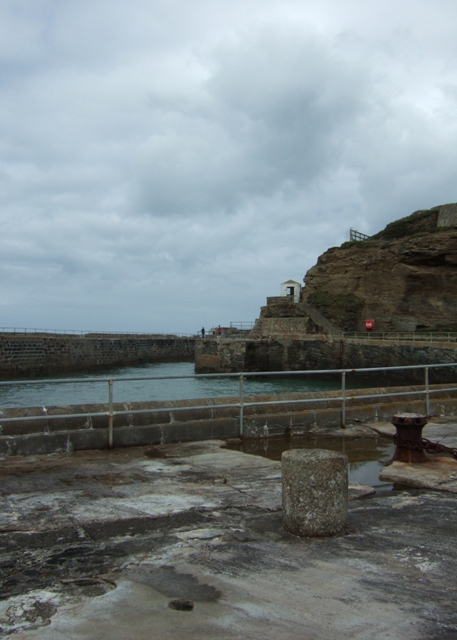
English: Harbour approach, Portreath This shows how long and narrow the harbour entry is. Many of the boats entering it in the C19th would have had to have been warped up its length by either horse or manpower.
The inland end of the pier dates from the 1760s and was extended out to sea in 1824. The pier is now locked and closed off behind fences to deter swimmers jumping into the harbour which is dangerous as it is deep and has a strong surge. The little white building is known as Deadman's Hut |
| Date | |
| Source | From geograph.org.uk |
| Author | Simon Huguet |
| Attribution (required by the license) | Simon Huguet / Harbour approach, Portreath / |
| Camera location | | View this and other nearby images on: OpenStreetMap |
|---|
_heading:337.00&language=en)
| Object location | | View this and other nearby images on: OpenStreetMap |
|---|
_heading:337.00&language=en)
Licensing
[edit]

|
This image was taken from the Geograph project collection. See this photograph's page on the Geograph website for the photographer's contact details. The copyright on this image is owned by Simon Huguet and is licensed for reuse under the Creative Commons Attribution-ShareAlike 2.0 license.
|
This file is licensed under the Creative Commons Attribution-Share Alike 2.0 Generic license.
Attribution: Simon Huguet
- You are free:
- to share – to copy, distribute and transmit the work
- to remix – to adapt the work
- Under the following conditions:
- attribution – You must give appropriate credit, provide a link to the license, and indicate if changes were made. You may do so in any reasonable manner, but not in any way that suggests the licensor endorses you or your use.
- share alike – If you remix, transform, or build upon the material, you must distribute your contributions under the same or compatible license as the original.
File history
Click on a date/time to view the file as it appeared at that time.
| Date/Time | Thumbnail | Dimensions | User | Comment | |
|---|---|---|---|---|---|
| current | 02:48, 22 February 2011 | | 457 × 640 (128 KB) | GeographBot (talk | contribs) | == {{int:filedesc}} == {{Information |description={{en|1=Harbour approach, Portreath This shows how long and narrow the harbour entry is. Many of the boats entering it in the C19th would have had to have been warped up its length by either horse or manpow |
You cannot overwrite this file.
File usage on Commons
There are no pages that use this file.