File:Hannibal route of invasion-fr.svg
Jump to navigation
Jump to search

Size of this PNG preview of this SVG file: 764 × 479 pixels. Other resolutions: 320 × 201 pixels | 640 × 401 pixels | 1,024 × 642 pixels | 1,280 × 803 pixels | 2,560 × 1,605 pixels.
Original file (SVG file, nominally 764 × 479 pixels, file size: 760 KB)
Captions
Captions
Add a one-line explanation of what this file represents
Summary
[edit]| Description |
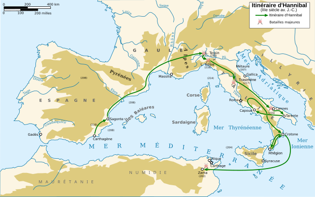
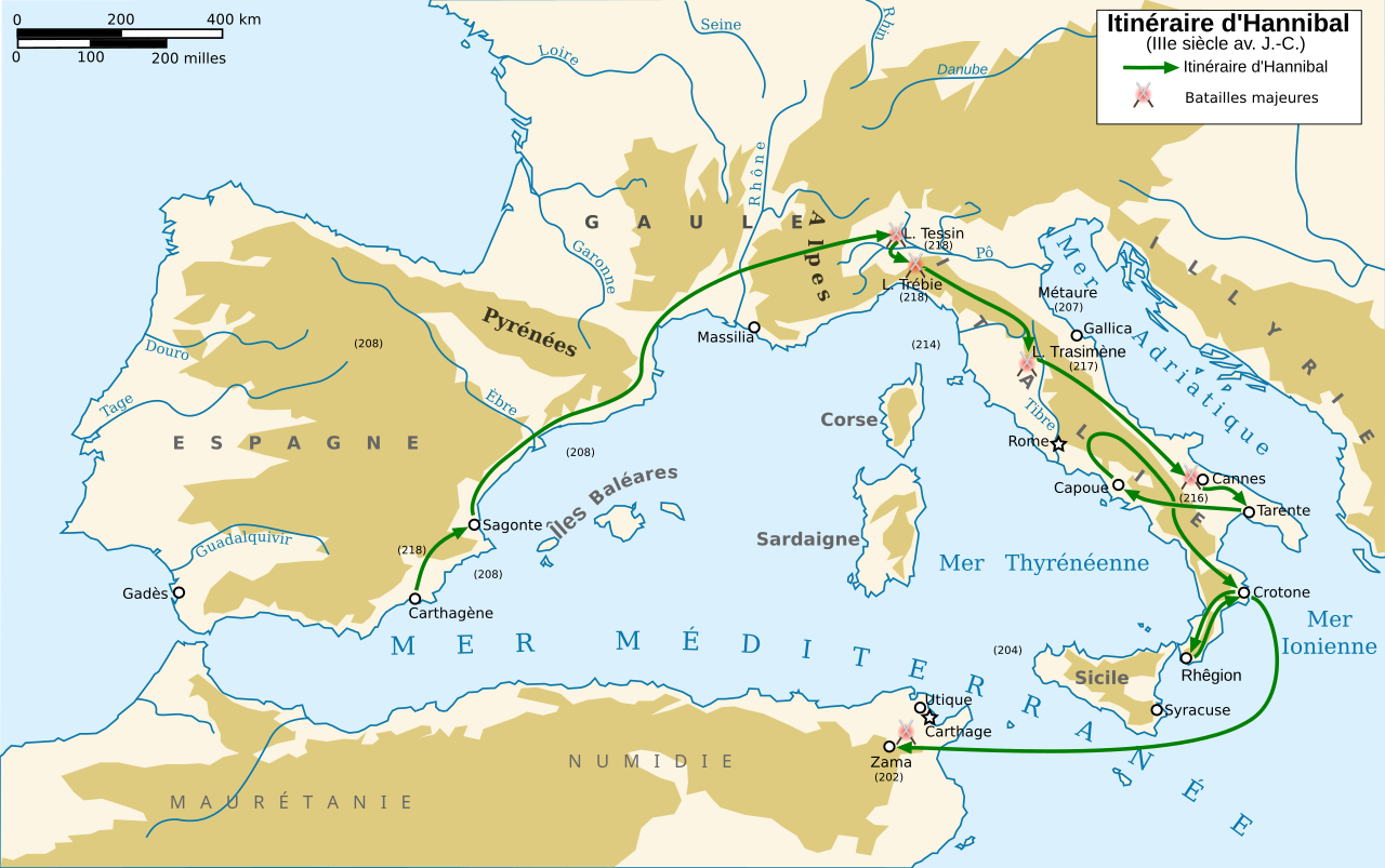
Français : Carte en français de la route empruntée par Hannibal durant son invasion
English: Map in french of Hannibal's route of invasion |
| Date | |
| Source | Travail personnel. La carte est vectorisée à partir de Image:Europe_topography_map.png. Les lieux sont repérés grâce à Image:Hannibal route of invasion.gif, Image:Second Punic War full.svg et cette carte sur Britannica. |
| Author | Abalg |
| Other versions |
[]
|


This W3C-unspecified vector image was created with Inkscape .

|
This SVG file contains embedded text that can be translated into your language, using any capable SVG editor, text editor or the SVG Translate tool. For more information see: About translating SVG files. |
Licensing
[edit]
I, the copyright holder of this work, hereby publish it under the following licenses:

|
Permission is granted to copy, distribute and/or modify this document under the terms of the GNU Free Documentation License, Version 1.2 or any later version published by the Free Software Foundation; with no Invariant Sections, no Front-Cover Texts, and no Back-Cover Texts. A copy of the license is included in the section entitled GNU Free Documentation License. |
This file is licensed under the Creative Commons Attribution-Share Alike 3.0 Unported, 2.5 Generic, 2.0 Generic and 1.0 Generic license.
- You are free:
- to share – to copy, distribute and transmit the work
- to remix – to adapt the work
- Under the following conditions:
- attribution – You must give appropriate credit, provide a link to the license, and indicate if changes were made. You may do so in any reasonable manner, but not in any way that suggests the licensor endorses you or your use.
- share alike – If you remix, transform, or build upon the material, you must distribute your contributions under the same or compatible license as the original.
You may select the license of your choice.
File history
Click on a date/time to view the file as it appeared at that time.
| Date/Time | Thumbnail | Dimensions | User | Comment | |
|---|---|---|---|---|---|
| current | 12:20, 1 January 2014 | | 764 × 479 (760 KB) | Trlkly (talk | contribs) | Previous version accidentally had misalignment between landmasses and water on the edges of the image. |
| 12:08, 1 January 2014 |  | 764 × 479 (760 KB) | Trlkly (talk | contribs) | Removed both manual border and water border. Resized viewport to hide edge borders on landmasses. | |
| 20:38, 13 February 2008 |  | 770 × 486 (897 KB) | Pinpin (talk | contribs) | ||
| 22:10, 12 February 2008 |  | 770 × 486 (917 KB) | Pinpin (talk | contribs) | == Description == {{Information |Description={{fr|Carte en français de la route empruntée par Hannibal durant son invasion}} |Source=Travail personnel. La carte est vectorisée à partir de Image:Europe_topography_map.png. Les lieux sont repérés |
You cannot overwrite this file.
File usage on Commons
The following 21 pages use this file:
- File:Hannibal route of invasion-ar.gif
- File:Hannibal route of invasion-ar.png
- File:Hannibal route of invasion-en.svg
- File:Hannibal route of invasion-es.svg
- File:Hannibal route of invasion-fr.svg
- File:Hannibal route of invasion-gl.svg
- File:Hannibal route of invasion-hu.svg
- File:Hannibal route of invasion-it.svg
- File:Hannibal route of invasion-nl.png
- File:Hannibal route of invasion-nl.svg
- File:Hannibal route of invasion-pt.svg
- File:Hannibal route of invasion-zh-classical.png
- File:Hannibal route of invasion-zh.svg
- File:Hannibal route of invasion.gif
- File:Hannibal route of invasion - de.svg
- File:Hannibal route of invasion - en.svg
- File:Hannibal route of invasion - ka.svg
- File:Hannibal route of invasion - ru.svg
- File:Hannibal route of invasion de 2.svg
- File:Percorso di invasione di Annibale.png
- Template:Other versions/Hannibal route of invasion
File usage on other wikis
The following other wikis use this file:
- Usage on fr.wikipedia.org
- Usage on la.wikipedia.org