File:Hamburg Gliederung 1875.svg
Jump to navigation
Jump to search

Size of this PNG preview of this SVG file: 608 × 548 pixels. Other resolutions: 266 × 240 pixels | 533 × 480 pixels | 852 × 768 pixels | 1,136 × 1,024 pixels | 2,272 × 2,048 pixels.
Original file (SVG file, nominally 608 × 548 pixels, file size: 250 KB)
Captions
Captions
Add a one-line explanation of what this file represents
Summary
[edit]| Description |
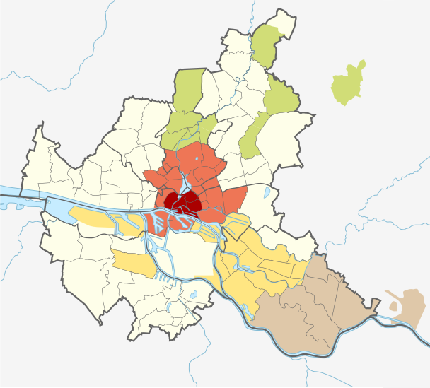
Deutsch: Gliederung des Hamburger Staatsgebietes um 1875 (Projektion auf die heutigen Bezirks- und Stadtteilgrenzen sowie Geesthacht in den Grenzen von 1937):
Stadt Hamburg mit St. Georg (seit 1868)
Vorstadt St. Pauli und 15 weitere „Vororte“ (ab 1894 Stadtteile)
Landherrenschaft der Geestlande
Landherrenschaft der Marschlande
Landherrenschaft Bergedorf
nicht im Bild: Landherrenschaft Ritzebüttel (hamburgische Exklave an der Elbmündung) |
| Date | |
| Source | Own work using: Germany Hamburg adm location map.svg by NordNordWest |
| Author | Uwe Rohwedder |
| Other versions |
|


Licensing
[edit]
I, the copyright holder of this work, hereby publish it under the following license:
This file is licensed under the Creative Commons Attribution-Share Alike 3.0 Unported license.
- You are free:
- to share – to copy, distribute and transmit the work
- to remix – to adapt the work
- Under the following conditions:
- attribution – You must give appropriate credit, provide a link to the license, and indicate if changes were made. You may do so in any reasonable manner, but not in any way that suggests the licensor endorses you or your use.
- share alike – If you remix, transform, or build upon the material, you must distribute your contributions under the same or compatible license as the original.
File history
Click on a date/time to view the file as it appeared at that time.
| Date/Time | Thumbnail | Dimensions | User | Comment | |
|---|---|---|---|---|---|
| current | 15:08, 26 January 2018 | | 608 × 548 (250 KB) | UweRohwedder (talk | contribs) | korrektur st. pauli (war noch vorstadt, nicht stadtteil) |
| 15:01, 26 January 2018 |  | 608 × 548 (250 KB) | UweRohwedder (talk | contribs) | sichtbarer ausschnitt nach osten (geesthacht) erweitert, kleinere korrekturen, flächen neu gefüllt | |
| 12:56, 20 January 2018 |  | 558 × 548 (268 KB) | UweRohwedder (talk | contribs) | {{Information |Description ={{de|1=Gliederung des Hamburger Staatsgebietes um 1875 (Projektion auf die heutigen Bezirks- und Stadtteilgrenzen): {{legend|#800000|Stadt Hamburg mit St. Georg (seit 1868)}} {{legend|#EE7656|Vor... |
You cannot overwrite this file.
File usage on Commons
The following 3 pages use this file:
File usage on other wikis
The following other wikis use this file: