File:Hamamatsu I.C(1975 - 2015).svg
Jump to navigation
Jump to search

Size of this PNG preview of this SVG file: 800 × 471 pixels. Other resolutions: 320 × 188 pixels | 640 × 377 pixels | 1,024 × 603 pixels | 1,280 × 754 pixels | 2,560 × 1,508 pixels | 1,949 × 1,148 pixels.
Original file (SVG file, nominally 1,949 × 1,148 pixels, file size: 3.81 MB)
Captions
Captions
Add a one-line explanation of what this file represents
Summary
[edit].svg&action=edit§ion=1)
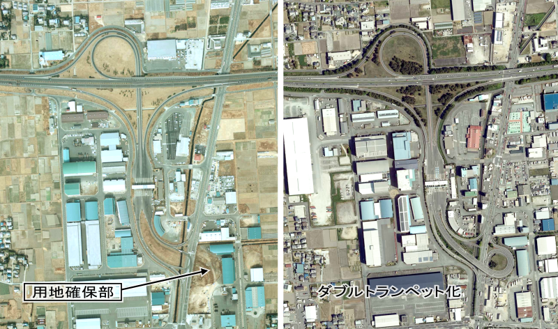
| Description | 東名高速道路 浜松インターチェンジの1975年と2015年時点の比較写真 |
| Date | |
| Source | 国土交通省 国土画像情報(カラー空中写真)を基に加工 |
| Author | 国土地理院 |
Licensing
[edit].svg&action=edit§ion=2)

|
The copyright holder of this file, the Ministry of Land, Infrastructure, Transport and Tourism of Japan, allows anyone to use it for any purpose, provided that the copyright holder is properly attributed. Redistribution, derivative work, commercial use, and all other use is permitted. |
Attribution:
Copyright © National Land Image Information (Color Aerial Photographs), Ministry of Land, Infrastructure, Transport and Tourism
|
 |
This image is copyrighted by the Ministry of Land, Infrastructure, Transport and Tourism of Japan. For terms of use, see the stipulation to use of National Land Information (in Japanese) and message from MLIT (in Japanese and English). When you display this image on an article, include the following phrase in the description: "Made based on National Land Image Information (Color Aerial Photographs), Ministry of Land, Infrastructure, Transport and Tourism".
|
File history
Click on a date/time to view the file as it appeared at that time.
| Date/Time | Thumbnail | Dimensions | User | Comment | |
|---|---|---|---|---|---|
| current | 07:37, 25 June 2022 | | 1,949 × 1,148 (3.81 MB) | Oka21000 (talk | contribs) | 矢印一本削除 |
| 07:03, 25 June 2022 |  | 1,949 × 1,148 (3.81 MB) | Oka21000 (talk | contribs) | {{Information |Description=東名高速道路 浜松インターチェンジの1975年と2015年時点の比較写真 |Source=国土交通省 [https://mapps.gsi.go.jp/maplibSearch.do#1 国土画像情報(カラー空中写真)]を基に加工 |Date=1975 |Author=国土地理院 |Permission= |other_versions= }} Category:Tomei Expressway in Shizuoka prefecture |
You cannot overwrite this file.
File usage on Commons
There are no pages that use this file.
File usage on other wikis
The following other wikis use this file:
- Usage on ja.wikipedia.org
.svg&oldid=668225220)