File:Hallonflickan Karta över Mönarpa mossar.jpg
Jump to navigation
Jump to search
Size of this preview: 481 × 600 pixels. Other resolutions: 192 × 240 pixels | 385 × 480 pixels | 616 × 768 pixels | 821 × 1,024 pixels | 1,642 × 2,048 pixels | 2,566 × 3,200 pixels.
Original file (2,566 × 3,200 pixels, file size: 2.67 MB, MIME type: image/jpeg)
Captions
Captions
Add a one-line explanation of what this file represents
Summary
[edit]
| Description |
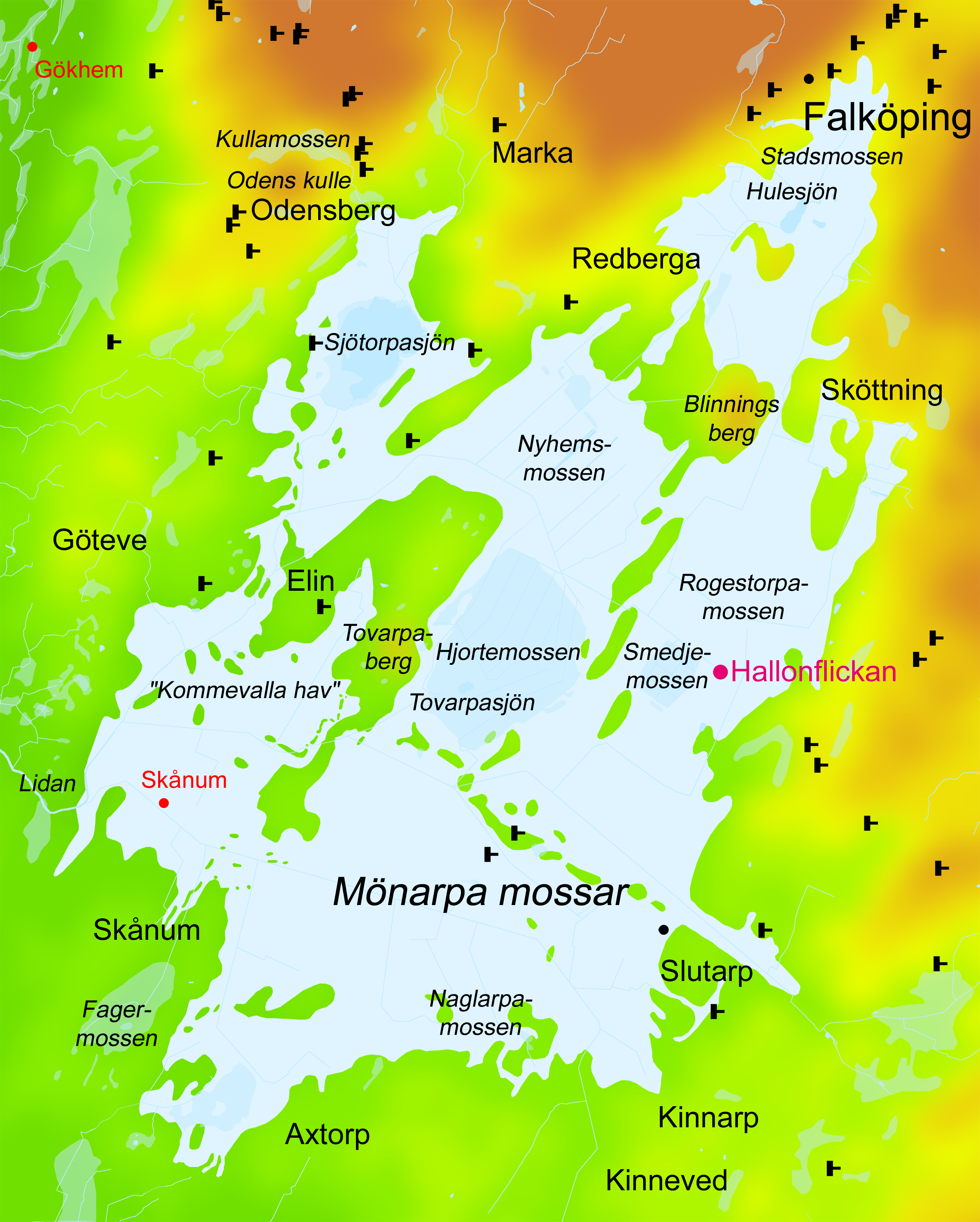
English: Exhibition picture (original file) created by the archaeologist Gunnar Creutz for the archaeological exhibition Hallonflickan (i.e. "The Raspberry Girl") in the summer of 2011 at Falbygdens museum in Falköping, former Skaraborg County, Västergötland, Västra Götaland County, Sweden.
Map over the bog complex Mönarpa mossar (Mönarp's bogs) in the municipality of Falköping, Västergötland (Westrogothia), Sweden. Scale circa 1:15,000. Land is green to red depending on altitude. Lakes and watercourses are light blue. Bogs are even lighter blue. Drained peat soil is the lightest blue. The site, where the Neolithic skeleton called "The Raspberry Girl" (Hallonflickan) was found, is marked red. The neolithic passage graves of the area are marked with black T-signs. The uploaded file is the original file that the exhibited picture was printed from. Svenska: Utställningsbild (originalbild) skapad av arkeologen Gunnar Creutz till den arkeologiska utställningen Hallonflickan sommaren 2011 på Falbygdens museum i Falköping. Karta över mosskomplexet Mönarpa mossar i Falköpings kommun, Västergötland, Sverige. Skala ungefär 1:15000. Kartan är gjord utifrån Geologiska kartan från 1905 och avser att ge en bild av hur området kan ha sett ut för 5000 år sedan under mellanneolitikum. Fastlandet är grönt till rött där rött markera högre höjd över havet (dock inga höjdkurvor). Nuvarande sjöar och vattendrag är ljusblå. Mossar är ännu ljusare blå. Utdikad mossmark är ljusast blå. Namngivna i kursiv stil är ån Lidan, sjöarna Sjötorpasjön, Tovarpasjön och Hulesjön, mossarna Mönarpa mossar, Naglarpamossen, Hjortemossen, Smedjemossen, Rogestorpamossen, Nyhems mossar och Stadsmossen, samt mossarna Fagermossen och Kullamossen. Namnen på kullarna Blinningsberg, Odens kulle och Tovarpaberg är utsatta. Fyndplatsen för det neolitiska mossfyndet Hallonflickan (RAÄ-nummer Luttra 29:1) är markerad med rött. Även fyndplatserna för två mossfynd av järnålderskvinnor från Bergsgårdens utmark i Gökhems socken och från Skånum i Grolanda socken är markerade med rött. Områdets neolitiska gånggrifter är markerade med svarta T-symboler. För att lättare kunna orientera sig på kartan är namnen på de moderna tätorterna Falköping, Odensberg, Kinnarp och Slutarp, socknarna Göteve, Kinneved och Marka, byarna Axtorp, Elin, Skånum och Sköttning, samt gården Redberga inlagda. Den uppladdade filen är originalfilen, som den utställda bilden skrevs ut från. |
| Date | |
| Source | Own work |
| Author | Gunnar Creutz, Falbygdens museum |
| Permission (Reusing this file) |
Please attribute the work to "Gunnar Creutz, Falbygdens museum". |
| Other versions |
 |
Licensing
[edit]
I, the copyright holder of this work, hereby publish it under the following license:
This file is licensed under the Creative Commons Attribution-Share Alike 3.0 Unported license.
- You are free:
- to share – to copy, distribute and transmit the work
- to remix – to adapt the work
- Under the following conditions:
- attribution – You must give appropriate credit, provide a link to the license, and indicate if changes were made. You may do so in any reasonable manner, but not in any way that suggests the licensor endorses you or your use.
- share alike – If you remix, transform, or build upon the material, you must distribute your contributions under the same or compatible license as the original.
File history
Click on a date/time to view the file as it appeared at that time.
| Date/Time | Thumbnail | Dimensions | User | Comment | |
|---|---|---|---|---|---|
| current | 08:17, 22 February 2013 | | 2,566 × 3,200 (2.67 MB) | Achird (talk | contribs) | User created page with UploadWizard |
You cannot overwrite this file.
File usage on Commons
The following 4 pages use this file:
File usage on other wikis
The following other wikis use this file:
- Usage on de.wikipedia.org
- Usage on es.wikipedia.org
- Usage on fa.wikipedia.org